|
|
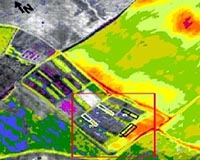
Redlands CA (SPX) Oct 29, 2009  Forestry Development Centre Tapio of Finland is using ESRI's ArcGIS software and a solution designed by Tieto, an ESRI business partner, to meet Forestry Centres' goal to decrease forest inventory costs by 40 percent. The solution is designed to improve productivity, cost efficiency, and cooperation between organizations, including data procurement and two-way dataflow. It will also ... read more
 Paris, France (ESA) Oct 29, 2009
The Galileo Master prize for 2009 has been awarded to Jose Caro Ramon for his use of satellite navigation to increase the effectiveness of rescue dogs searching for survivors after natural disasters. The ESA prize went to Tim Springer for his idea of centimetre-level satnav positioning in near-realtime. The European Satellite Navigation Competition (ESNC) covers 18 partner regions that ... more
|
| |||||||||||||||
| Previous Issues | Oct 28 | Oct 27 | Oct 26 | Oct 23 | Oct 22 |
| . |
 Washington (AFP) Oct 28, 2009
Internet giant Google unveiled a free navigation system for mobile phones Wednesday in a move seen as a potential challenge to the makers of standalone GPS navigation devices. US telecom carrier Verizon Wireless and US handset maker Motorola announced simultaneously that a smartphone going on sale in the United States next week, the Droid, would be the first to feature Google Maps Navigation ... more  Greenbelt MD (SPX) Oct 28, 2009
Three of the satellite instruments that will fly on an upcoming satellite mission called "FASTSAT" have been created at one NASA center and have arrived at another for more tests to ensure they are flight ready for launch. They're now at the Marshall Space Flight Center in Huntsville, Ala. for further testing. "FASTSAT" means "Fast, Affordable, Science and Technology Satellite." The ... more  Boulder CO (SPX) Oct 28, 2009
The first images taken by the WorldView-2 remote-sensing satellite designed and built by Ball Aerospace and Technologies for DigitalGlobe were released on October 20 - just 11 days after the satellite's successful launch from Vandenberg Air Force Base, Calif. DigitalGlobe released images of Love Field Airport near Dallas and the AT and T Center in San Antonio, Texas. More refinements to ... more |
. |
|
|
. |
 Paris, France (ESA) Oct 16, 2009
Using satellite radar data and GPS measurements, Chinese researchers have explained the exceptional geological events leading to the 2008 Wenchuan Earthquake that killed nearly 90 000 people in China's Sichuan Province. "One of the very fundamental issues for understanding an earthquake is to know how the rupture is distributed on the fault plane, which is directly related to the amount of ... more  Redlands CA (SPX) Oct 14, 2009
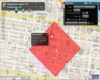
Philadelphia Police Department (PPD) in Pennsylvania uses an advanced enterprise geographic information system (GIS) platform that gives staff the ability to analyze millions of records and make better decisions. GIS applications allow officers to accurately map crime rates and patterns and ultimately make more arrests. "GIS gives us a platform to build from," says Michael Urciuoli, GIS ... more  La Jolla CA (SPX) Oct 14, 2009
Blue Sky Network has announced Nigerian-based Max Air selected Blue Sky Network's automated flight following and communication devices for its fleet of planes. Max Air will particularly depend on this safety equipment in late November during the Hajj, an annual Muslim pilgrimage to the Islamic Holy Land that has traditionally been plagued with travel difficulties. To ensure safe and timely ... more |
. |
| Previous Issues | Oct 28 | Oct 27 | Oct 26 | Oct 23 | Oct 22 |
| The contents herein, unless otherwise known to be public domain, are Copyright 1995-2009 - SpaceDaily. AFP and UPI Wire Stories are copyright Agence France-Presse and United Press International. ESA Portal Reports are copyright European Space Agency. All NASA sourced material is public domain. Additional copyrights may apply in whole or part to other bona fide parties. Advertising does not imply endorsement, agreement or approval of any opinions, statements or information provided by SpaceDaily on any web page published or hosted by SpaceDaily. Privacy statement |