|
|
Buckingham, UK (SPX) Oct 26, 2009 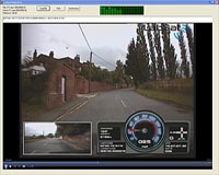 Since its release in March, the new LabSat has already made a mark on the GPS Simulator market, with uptake from a number of large GPS product manufacturers looking for realistic and repeatable testing. Development has continued at the same pace, and Racelogic have now announced a new capability for LabSat in the form of video synchronisation. Using a Racelogic Video VBOX, a GPS data ... read more
 Rio De Janeiro (AFP) Oct 17, 2009
Rio's favelas are home to a third of the city's population, but are almost invisible on maps -- a situation five young women are trying to change with the help of GPS and the Internet. Rafaela Goncalves da Silva, 21, has lived in the Santa Marta favela, a poor and dangerous slum that was recently the target of a police pacification operation, since she was two years old. She is bringing ... more
|
| |||||||||||||||
| Previous Issues | Oct 23 | Oct 22 | Oct 21 | Oct 20 | Oct 19 |
| . |
 Redlands CA (SPX) Oct 19, 2009
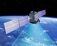
Secretary of the Interior Ken Salazar recently signed an order to establish a coordinated strategy within the United States Department of the Interior (DOI) to improve response to climate change. During the press conference announcing the order, DOI staff used ESRI geographic information system (GIS) technology to demonstrate the current and future impacts of global climate change. ... more  Jerusalem (AFP) Oct 18, 2009
Navigating the contours of the Israeli-Palestinian conflict can be confusing -- even for satellite navigation systems. But soon, if the Israeli army has its way, the Global Positioning System (GPS) will get a lesson in the political complexities of the disputed region. The military has approached the company that makes the maps for the personal navigation devices, asking them to ... more  Amsterdam (AFP) Oct 18, 2009
About a hundred houses float on a lake in the Amsterdam neighbourhood of Ijburg -- a testament to how the Dutch are trying to turn their traditional enemy, water, into an ally against overcrowding. "There is a lot of water in the Netherlands, it is used for navigation and recreation. We want to see if it can also be inhabited," Ton van Namen, director of real estate company Monteflore, told ... more |
. |
|
|
. |
 San Antonio TX (SPX) Oct 13, 2009
DigitalGlobe's recently launched WorldView-2 satellite provides an unprecedented level of detail and geospatial accuracy for imaging and mapping the Earth's surface. Operating at an altitude of 770 kilometers, WorldView-2 features an advanced onboard imaging system with better than 0.5-meter panoramic resolution and 1.8-meter multispectral resolution and is capable of collecting images of up to ... more CSR has introduced the SiRFstarIV GSD4e GPS location processor, the newest member of the recently launched SiRFstarIV architecture, an innovation that promises to redefine the meaning of "location awareness" for mobile devices. Building upon the SiRFstarIV architecture's high-performance and micro-power capabilities, the GSD4e adds a built-in CPU and innovations such as SiRFGeoRecov ... more  St. Louis MO (SPX) Oct 13, 2009
Boeing has signed Foreign Military Sales (FMS) contracts with the U.S. government to provide Laser Joint Direct Attack Munitions (JDAM) to two international customers. The FMS contracts are part of a $98 million indefinite delivery, indefinite quantity contract for Laser JDAM production and integration that Boeing received in August. The weapons are scheduled for delivery in 2010. ... more |
. |
| Previous Issues | Oct 23 | Oct 22 | Oct 21 | Oct 20 | Oct 19 |
| The contents herein, unless otherwise known to be public domain, are Copyright 1995-2009 - SpaceDaily. AFP and UPI Wire Stories are copyright Agence France-Presse and United Press International. ESA Portal Reports are copyright European Space Agency. All NASA sourced material is public domain. Additional copyrights may apply in whole or part to other bona fide parties. Advertising does not imply endorsement, agreement or approval of any opinions, statements or information provided by SpaceDaily on any web page published or hosted by SpaceDaily. Privacy statement |