|
|
Delhi, India (SPX) Oct 08, 2009  Part of India's growing power demands will soon be met with smart grid technologies that improve efficiency and reliability for businesses and consumers. North Delhi Power Limited (NDPL) has announced it would become the first major utility in India to realize the performance advantages of an advanced outage management system (OMS). A joint venture between Tata Power, India's largest ... read more
 Manama, Bahrain (UPI) Oct 5, 2009
 In line with its bid to take on a leading role in international shipping, Bahrain has become the first Arab state to tap into a global ship-tracking system. The system will allow Bahrain to bolster its coastal security and maritime rescue operations. It will also be able to better track its own growing fleet of vessels round the globe, within an estimated 1,000 miles of its coast ... more
|
| |||||||||||||||
| Previous Issues | Oct 07 | Oct 06 | Oct 05 | Oct 02 | Oct 01 |
| . |
 Pasadena CA (SPX) Oct 06, 2009
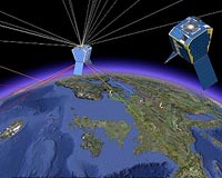
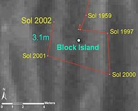
NASA's Mars Exploration Rover Opportunity has found a rock that apparently is another meteorite, less than three weeks after driving away from a larger meteorite that the rover examined for six weeks. Opportunity used its navigation camera during the mission's 2,022nd Martian day, or sol, (Oct. 1, 2009) to take this image of the apparent meteorite dubbed "Shelter Island." The pitted ... more Mr Antonio Tajani, European Commission Vice-President for Transport Policy, has announced the official start of operations for EGNOS, the European Geostationary Navigation Overlay Service. The EGNOS 'Open Service' is now available. This is a major milestone for the project: its primary service is now available to all users equipped with EGNOS-compatible receivers. Most mass-market satellite ... more 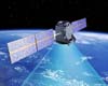 London, UK (SPX) Oct 02, 2009
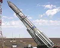
Surrey Satellite Technology Ltd (SSTL) has successfully completed the planned repositioning of the first Galileo test satellite, GIOVE-A, to a higher orbit to make way for the operational satellites of Europe's satellite navigation constellation. From the GIOVE-A operational headquarters in Guildford, UK, SSTL's operating team executed a series of precisely planned manoeuvres during July ... more |
. |
|
|
. |
 Denver CO (SPX) Sep 28, 2009
The world's first commercial, high-resolution, Earth imaging satellite, IKONOS, will achieve its 10th year of operation on Sept. 24. Built by Lockheed Martin, the satellite continues to provide high-resolution imagery of the Earth to commercial and government customers around the world. IKONOS is owned and operated by GeoEye of Dulles, Va. "When we launched IKONOS in ... more  San Diego, California (AFP) Sept 24, 2009
Technology startup Waze is tapping into the collective knowledge of road warriors in order to make life more pleasant for drivers while creating reliable street maps. A free Waze: Way to Go service that proved its worth in Israel is making its US debut, inviting motorists to use smart phones to keep one another in the know about speed traps, short cuts, hazards, accidents and more. ... more 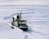 Geneva (AFP) Sept 23, 2009
Canada, Norway and Russia will soon provide navigation and meteorological warnings for ships crossing the Arctic sea, a new maritime route which has opened up due to global warming, a WMO expert said Wednesday. A revised Manual on Maritime Safety Information which is to come into force in 2011 now includes the Arctic as a new zone, divided into five areas where weather warnings would have to ... more |
. |
| Previous Issues | Oct 07 | Oct 06 | Oct 05 | Oct 02 | Oct 01 |
| The contents herein, unless otherwise known to be public domain, are Copyright 1995-2009 - SpaceDaily. AFP and UPI Wire Stories are copyright Agence France-Presse and United Press International. ESA Portal Reports are copyright European Space Agency. All NASA sourced material is public domain. Additional copyrights may apply in whole or part to other bona fide parties. Advertising does not imply endorsement, agreement or approval of any opinions, statements or information provided by SpaceDaily on any web page published or hosted by SpaceDaily. Privacy statement |