|
|
Pasadena CA (SPX) Sep 21, 2009 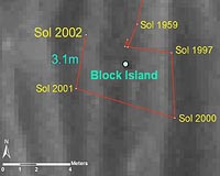 Opportunity completed the circumnavigation and full-circle imaging of the large meteorite "Block Island" and has resumed the long drive to Endeavour crater. On Sol 2001 (Sept. 9, 2009), the rover moved 9 meters (30 feet) around the meteorite to the fourth and fifth out of six planned positions. On the next sol Opportunity reached the sixth and final position around Block Island with ... read more
 Greenbelt MD (SPX) Sep 18, 2009
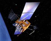
Noreen Thomas' farm looks like a patchwork quilt. Fields change hue with the season and with the alternating plots of organic wheat, soybeans, corn, alfalfa, flax, or hay. Thomas enjoys this view from hundreds of miles above Earth's surface - not just for the beauty, but the utility. She is among a growing group of Midwest farmers who rely on satellite imagery from Landsat to maximize ... more
|
| |||||||||||||||
| Previous Issues | Sep 20 | Sep 17 | Sep 16 | Sep 15 | Sep 14 |
| . |
 St. Louis MO (SPX) Sep 18, 2009
A Boeing Harpoon Block II missile equipped with a redesigned Guidance Control Unit (GCU) flew for the first time in a test conducted on Sept. 10. It was launched from the USS Princeton off the coast of California and scored a direct hit on a land-based target on San Nicolas Island, Calif. The new GCU, which controls most of the missile's functions, incorporates a Selective Availability ... more  Grand Forks ND (SPX) Sep 17, 2009
Noreen Thomas' farm looks like a patchwork quilt. Fields change hue with the season and with the alternating plots of organic wheat, soybeans, corn, alfalfa, flax, or hay. Thomas enjoys this view from hundreds of miles above Earth's surface - not just for the beauty, but the utility. She is among a growing group of Midwest farmers who rely on satellite imagery from Landsat to maximize thei ... more  Moscow, Russia (RIA Novosti) Sep 16, 2009
Russia will launch a Proton-M carrier rocket on September 25 from the Baikonur space center in Kazakhstan to orbit three Glonass navigation satellites, Russia's Federal Space Agency Roscosmos said on Tuesday. Glonass - the Global Navigation Satellite System - is the Russian equivalent of the U.S. Global Positioning System, or GPS, and is designed for both military and civilian use. Both ... more |
. |
|
|
. |
 Tempe AZ (SPX) Sep 02, 2009
Some slow-moving faults may help protect some regions of Italy and other parts of the world against destructive earthquakes, suggests new research from The University of Arizona in Tucson. Until now, geologists thought when the crack between two pieces of the Earth's crust was at a very gentle slope, there was no movement along that particular fault line. "This study is the first to ... more The U.S. electric system, "the supreme engineering achievement of the 20th century," is aging, inefficient, congested, and incapable of meeting future energy needs, according to a recent U.S. Department of Energy (DOE) report. As electric utilities work to overcome challenges laid out in the DOE report, they can find guidance in a new benchmark study that focuses on a smart grid and ... more  St. Louis MO (SPX) Sept 01, 2009
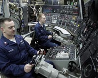
Boeing will demonstrate its ground robotics capabilities at the U.S. Army's first Robotics Rodeo, to be held Sept. 1-3 at Fort Hood, Texas. The event is sponsored by the Army's Tank Automotive Research, Development and Engineering Center (TARDEC) and Fort Hood's III Corps. The event is an opportunity for industry to demonstrate to Army and government officials how the latest robotic ... more |
. |
| Previous Issues | Sep 20 | Sep 17 | Sep 16 | Sep 15 | Sep 14 |
| The contents herein, unless otherwise known to be public domain, are Copyright 1995-2009 - SpaceDaily. AFP and UPI Wire Stories are copyright Agence France-Presse and United Press International. ESA Portal Reports are copyright European Space Agency. All NASA sourced material is public domain. Additional copyrights may apply in whole or part to other bona fide parties. Advertising does not imply endorsement, agreement or approval of any opinions, statements or information provided by SpaceDaily on any web page published or hosted by SpaceDaily. Privacy statement |