|
|
Grand Forks ND (SPX) Sep 17, 2009 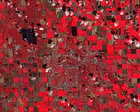 Noreen Thomas' farm looks like a patchwork quilt. Fields change hue with the season and with the alternating plots of organic wheat, soybeans, corn, alfalfa, flax, or hay. Thomas enjoys this view from hundreds of miles above Earth's surface - not just for the beauty, but the utility. She is among a growing group of Midwest farmers who rely on satellite imagery from Landsat to maximize thei ... read more
 Moscow, Russia (RIA Novosti) Sep 16, 2009
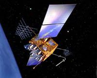
Russia will launch a Proton-M carrier rocket on September 25 from the Baikonur space center in Kazakhstan to orbit three Glonass navigation satellites, Russia's Federal Space Agency Roscosmos said on Tuesday. Glonass - the Global Navigation Satellite System - is the Russian equivalent of the U.S. Global Positioning System, or GPS, and is designed for both military and civilian use. Both ... more
|
| |||||||||||||||
| Previous Issues | Sep 16 | Sep 15 | Sep 14 | Sep 13 | Sep 11 |
| . |
 Charlottesville VA (SPX) Sep 15, 2009
Northrop Grumman's Sperry Marine business unit has announced that the Chief of Naval Operations (CNO) has approved the latest upgrade to its electronic navigation software for U.S. Navy submarines. Version 8.3 of Sperry Marine's Voyage Management System (VMS) was approved for submarines by CNO following an extensive certification testing program carried out by engineers from Naval Surface ... more  Redlands CA (SPX) Sep 14, 2009
The French Service de l'Information Aeronautique (SIA), headquartered in the Bordeaux-Merignac Airport in the town of Merignac, France, has awarded a contract for an aeronautical information management (AIM) system based on ESRI's geographic information system (GIS) software. The contract was awarded to ESRI France, and French aeronautical technology companies Thales and CGx AERO in SYS ... more  London, UK (SPX) Sep 14, 2009
Rockwell Collins has been selected by the United Kingdom (UK) Ministry of Defence (MoD) to provide significant additional FireStorm targeting systems to help UK Forward Air Controllers and Forward Artillery Observers to accurately direct aircraft and artillery to their targets. The order also includes spares to support overall system deployments in Afghanistan. "This is the second major ... more |
. |
|
|
. |
 Kampala (AFP) Aug 31, 2009
Users of the social networking sites Facebook and Twitter will be able to "befriend" rare Ugandan mountain gorillas and track their movements, a Wildlife Authority spokeswoman said Monday. In a scheme designed to promote Uganda's nascent tourism industry, users will receive regular updates about their endangered primate friends, Lillian Nsubuga told AFP. "Through geo-tracking and GPS ... more  Blacksburg VA (SPX) Aug 31, 2009
Members of Virginia Tech's Space@VT research group are receiving a $2 million grant from the National Science Foundation (NSF) to build a chain of space weather instrument stations in Antarctica. Space weather affects a variety of everyday consumer technologies including global positioning systems (GPS), satellites for television reception, and cellular phones. Also, the understanding of space ... more  Washington DC (SPX) Aug 28, 2009
With a very lucky shot, scientists have captured a one-second image and the electrical fingerprint of huge lightning that flowed 40 miles upward from the top of a storm. These rarely seen, highly charged meteorological events are known as gigantic jets, and they flash up to the lower levels of space, or ionosphere. While they don't occur every time there is lightning, they are ... more |
. |
| Previous Issues | Sep 16 | Sep 15 | Sep 14 | Sep 13 | Sep 11 |
| The contents herein, unless otherwise known to be public domain, are Copyright 1995-2009 - SpaceDaily. AFP and UPI Wire Stories are copyright Agence France-Presse and United Press International. ESA Portal Reports are copyright European Space Agency. All NASA sourced material is public domain. Additional copyrights may apply in whole or part to other bona fide parties. Advertising does not imply endorsement, agreement or approval of any opinions, statements or information provided by SpaceDaily on any web page published or hosted by SpaceDaily. Privacy statement |