|
|
Charlottesville VA (SPX) Sep 15, 2009  Northrop Grumman's Sperry Marine business unit has announced that the Chief of Naval Operations (CNO) has approved the latest upgrade to its electronic navigation software for U.S. Navy submarines. Version 8.3 of Sperry Marine's Voyage Management System (VMS) was approved for submarines by CNO following an extensive certification testing program carried out by engineers from Naval Surface ... read more
 Redlands CA (SPX) Sep 14, 2009
The French Service de l'Information Aeronautique (SIA), headquartered in the Bordeaux-Merignac Airport in the town of Merignac, France, has awarded a contract for an aeronautical information management (AIM) system based on ESRI's geographic information system (GIS) software. The contract was awarded to ESRI France, and French aeronautical technology companies Thales and CGx AERO in SYS ... more
|
| |||||||||||||||
| Previous Issues | Sep 14 | Sep 13 | Sep 11 | Sep 10 | Sep 09 |
| . |
 London, UK (SPX) Sep 14, 2009
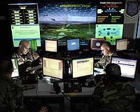
Rockwell Collins has been selected by the United Kingdom (UK) Ministry of Defence (MoD) to provide significant additional FireStorm targeting systems to help UK Forward Air Controllers and Forward Artillery Observers to accurately direct aircraft and artillery to their targets. The order also includes spares to support overall system deployments in Afghanistan. "This is the second major ... more  Pasadena CA (SPX) Sep 11, 2009
Opportunity has commenced circumnavigation and full-circle imaging of the large meteorite "Block Island". On Sol 1997 (Sept. 5, 2009), the rover moved 5.7 meters (18.7 feet) to the second of six stand-off positions around the meteorite (the first position being the initial rover location). At each location Opportunity collects a set of images with the panoramic camera (Pancam). ... more  Newtown PA (SPX) Sep 04, 2009
The last in a series of eight modernized Global Positioning System IIR (GPS IIR-M) satellites built by Lockheed Martin has been declared operational by the U.S. Air Force for military and civilian navigation users around the globe. The satellite, known as GPS IIR-21(M), was launched successfully from Cape Canaveral Air Force Station on Aug. 17. Lockheed Martin's operations team assisted ... more |
. |
|
|
. |
 Washington DC (SPX) Aug 28, 2009
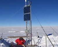
With a very lucky shot, scientists have captured a one-second image and the electrical fingerprint of huge lightning that flowed 40 miles upward from the top of a storm. These rarely seen, highly charged meteorological events are known as gigantic jets, and they flash up to the lower levels of space, or ionosphere. While they don't occur every time there is lightning, they are ... more  Sunnyvale CA (SPX) Aug 28, 2009
Trimble has introduced the Trimble AllTrak Asset Management System for contractors to manage their construction equipment and tools such as drills, ladders, compressors, nailers, and consumables. With accurate tracking information about asset usage, contractors can increase their efficiency while confidently managing acquisition, maintenance, and eventual retirement of their tools, equipment, an ... more  Redlands CA (SPX) Aug 28, 2009
States searching for a way to participate in the U.S. State Broadband Data and Development Program now have a solution with BroadbandStat, ESRI's new Web application that provides tools for mapping broadband coverage and planning broadband initiatives. Federal broadband stimulus funds available in the United States offer an unprecedented opportunity for states to improve their broadband in ... more |
. |
| Previous Issues | Sep 14 | Sep 13 | Sep 11 | Sep 10 | Sep 09 |
| The contents herein, unless otherwise known to be public domain, are Copyright 1995-2009 - SpaceDaily. AFP and UPI Wire Stories are copyright Agence France-Presse and United Press International. ESA Portal Reports are copyright European Space Agency. All NASA sourced material is public domain. Additional copyrights may apply in whole or part to other bona fide parties. Advertising does not imply endorsement, agreement or approval of any opinions, statements or information provided by SpaceDaily on any web page published or hosted by SpaceDaily. Privacy statement |