| May 21, 2009 |  |
GPS Daily Advertising Kit |
|
Herndon VA (SPX) May 20, 2009  Northrop Grumman's Hunter Unmanned Aircraft System (UAS), in use with the U.S. Army since 1996, recently surpassed 75,000 flight hours in service, 50,000 of which were flown in combat. The MQ-5B Hunter, which is currently deployed in the Global War on Terrorism, provides warfighters with state-of-the-art reconnaissance, surveillance, target acquisition (RSTA), communications relay, and wea ... read more
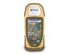 Livermore CA (SPX) May 19, 2009
Topcon Positioning Systems' (TPS) new GRS-1 is a modular, all-in-one, dual-constellation mapping system that incorporates high-accuracy capabilities into a single, small hand-held device. The GRS-1 has a high-speed processor, increased memory, built-in compass and an integrated digital camera and cell phone modem that provides flexibility for the user in the field. The GRS-1 addresses mobi ... more
|
| |||||||||||||||
| Previous Issues | May 20 | May 19 | May 18 | May 16 | May 15 |
|
An innovative online forum has been recently launched to promote the exchange of knowledge in the field of GPS tracking. The website is an online discussion site, similar to a message board or bulletin board, which publishes and manages user-generated content. Rocky Mountain Tracking has created this online GPS forum in an effort to facilitate communication between leading experts in the ... more  San Diego CA (SPX) May 19, 2009
Cubic Defense Applications has reported more than $5 million in new orders from the U.S. Army and U.S. Navy for Cubic's AN/ARS-6 V12 Personnel Locator System (PLS), a compact and powerful receiver-transmitter used to locate downed pilots during combat search and rescue operations. All branches of U.S. armed services use Cubic personnel locator systems, as well as NATO combat search and res ... more  Denver CO (SPX) May 19, 2009
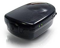
Intermap Technologies has announced that it has completed production of the first dataset of highly accurate 3D road vectors for Germany. Covering all classes of roads, the dataset features more than one million line kilometers of highly accurate road centerline position and elevation data for the entire country. Derived from the Company's recently completed database of uniformly accurate ... more Location Based Technologies has announced it completed and passed Federal Communications Commission (FCC) laboratory tests for both its PocketFinder and PetFinder devices. "FCC test completion is a major achievement not only for the company but towards delivery of product in the United States." said Dave Morse, CEO of Location Based Technologies. "We will start shipping working units ... more |
    |
|
 New York NY (SPX) May 13, 2009
The number of subscribers to handset-hosted location based services (LBS) increased in 2008 to more than 18 million. North America continued to be the dominant region, accounting for slightly more than two-thirds of the total market, according to a new study from ABI Research. While navigation continued to lead in terms of total subscribers, two other application areas - enterprise and com ... more  Washington DC (SPX) May 11, 2009
Although its peak is still four years away, a new active period of Earth-threatening solar storms will be the weakest since 1928, predicts an international panel of experts led by NOAA's Space Weather Prediction Center and funded by NASA. Despite the prediction, Earth is still vulnerable to a severe solar storm. Solar storms are eruptions of energy and matter that escape from the sun and ... more  San Diego CA (SPX) May 13, 2009
Trapster has just released version 2.4 of their iPhone app. The updated application includes Facebook Connect for the iPhone, Twitter integration, and multi-language support. Trapster iPhone users can now view the Trapmap and listen to trap notifications in the language of their preference, and automatically post the speed traps and road trips they create to their Facebook wall or Twitter ... more |
   |
 Lockheed Martin Reaches Core Mate Milestone on First GPS IIIF Satellite Slated for Launch
 Camera-only navigation system cuts localization drift by up to 95 percent without GPS or LiDAR
 Halter Smart Cattle Collars Go Direct-To-Satellite Expanding Virtual Fencing To Remote Ranches
 |
|
| Previous Issues | May 20 | May 19 | May 18 | May 16 | May 15 |
| The contents herein, unless otherwise known to be public domain, are Copyright 1995-2009 - SpaceDaily. AFP and UPI Wire Stories are copyright Agence France-Presse and United Press International. ESA Portal Reports are copyright European Space Agency. All NASA sourced material is public domain. Additional copyrights may apply in whole or part to other bona fide parties. Advertising does not imply endorsement, agreement or approval of any opinions, statements or information provided by SpaceDaily on any web page published or hosted by SpaceDaily. Privacy statement |


