 |
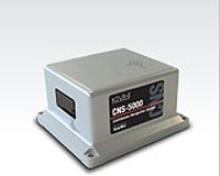
Middletown RI (SPX) May 08, 2009 KVH Industries has announced that it has received a new $1 million order for its CNS-5000, a self-contained navigation system that combines fiber optic gyro (FOG)-based inertial measurement technology from KVH with global positioning system (GPS) technology from NovAtel. This rugged navigation solution affordably provides the precise position and orientation of a host platform on a continuous basis, even during periods where GPS signals are blocked by natural or man-made obstructions or conditions. "This latest order, following on the heels of another $900,000 order a month ago, is evidence of the rapid acceptance of the CNS-5000 and the demand for a self-contained, commercial navigation solution," said Dan Conway, KVH's vice president of business development. "The CNS-5000's precision navigation and easy integration with a wide range of other systems make it an ideal solution for demanding commercial applications, such as dynamic surveying, precision agriculture, container terminal management, and autonomous vehicle navigation." The CNS-5000 offers seamless integration of KVH's FOG-based IMU with NovAtel's OEMV GPS precision receiver technology. The tight coupling of these technologies within the CNS-5000 optimizes the raw GPS and IMU data, delivering position data accurate to one inch along with superior velocity and attitude information. Composed entirely of commercial components and designed to meet COTS requirements, the CNS-5000 also minimizes the operational complexities for customers whose products cross international boundaries. Share This Article With Planet Earth
Related Links KVH Industries GPS Applications, Technology and Suppliers
 Redlands CA (SPX) May 05, 2009
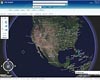
ArcGIS 9.3.1 helps you create and share modern Web maps that are relevant to your entire organization. This release of ESRI's integrated collection of geographic information system (GIS) software products focuses on improving the performance of dynamic map publishing and increasing the visibility of geographic information. |
|
| The content herein, unless otherwise known to be public domain, are Copyright 1995-2007 - SpaceDaily.AFP and UPI Wire Stories are copyright Agence France-Presse and United Press International. ESA Portal Reports are copyright European Space Agency. All NASA sourced material is public domain. Additional copyrights may apply in whole or part to other bona fide parties. Advertising does not imply endorsement,agreement or approval of any opinions, statements or information provided by SpaceDaily on any Web page published or hosted by SpaceDaily. Privacy Statement |
 del.icio.us
 Digg
Digg Reddit
 YahooMyWeb
 Google