|
|
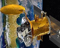
 Raytheon's First-of-Its-Kind Space-Based Hyperspectral Sensor Marks Second Year on Orbit
Paris, France (SPX) Jun 21, 2011 A groundbreaking space sensor built by Raytheon has completed its second year on orbit, exceeding its design life by 100 percent. The Advanced Responsive, Tactically Effective Military Imaging Sensor was launched aboard the Air Force Research Laboratory's TacSat-3 in May 2009. Originally slated for a one-year experimental mission, ARTEMIS performed so well that the U.S. Air Force Space Command took control of TacSat-3 for operational use in June 2010. ARTEMIS is a hyperspectral sensing syste ... read more |
. |

|
| Buy Advertising | Media Advertising Kit | Editorial & Other Enquiries | Privacy statement |
|
Free Newsletters - Delivered Daily Via Email - Space - War - Terra - Energy |
| .. |
 NASA/NOAA GOES Project Releases 2 Week Movie of Chilean Volcanic Eruption The NASA/NOAA GOES satellite Project released a satellite animation of two-weeks of eruptions from the Puyehue-Cordon Caulle volcano in Chile. The Geostationary Operational Environmental Satel ... more | .. |
 Landsat 5 Satellite Sees Mississippi River Floodwaters Lingering On May 19, 2011, the Mississippi River reached a historic crest at Vicksburg. According to the Advanced Hydrological Prediction Service (AHPS) of the U.S. National Weather Service, the river reached ... more | .. |
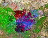 Landsat 5 Satellite Helps Emergency Managers Fight Largest Fire in Arizona History The largest fire in the history of the state of Arizona continues to burn and emergency managers and responders are using satellite data from a variety of instruments to plan their firefighting cont ... more | .. | ||
| .. |
 Cont-Trak offers reliable container tracking via satellite Whether at sea, on rail, stacked or stored, shipping containers can now be tracked worldwide via satellite with Cont-Trak, developed through ESA's telecommunications programme. Field trials ha ... more | .. |
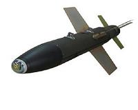 IAI to Unveil its new advanced Medium-weight Laser Guided Bomb Israel Aerospace Industries (IAI) will unveil the MLGB, a new advanced Medium-weight Laser Guided Bomb at the upcoming Le Bourget Airshow opens June 20th near Paris. MLGB is a dual mode Laser Guided ... more | .. |
 Thales completes flight demo for automatic landing of rotary wing UAVs Thales has announced that it has successfully achieved, with its partner Boeing, the full automatic landing of a one ton class VTOL (Vertical Take Off and Landing) UAV. The automatic landing was car ... more | .. |
 Raytheon Joint Standoff Weapon C-1 Completes Captive-Flight Test Series The U.S. Navy completed a series of captive-flight tests on Raytheon's Joint Standoff Weapon C-1, putting the warfighter one step closer to gaining a net-enabled standoff weapon with moving maritime ... more |
|
Free Newsletters - Delivered Daily Via Email - Space - War - Terra - Energy |
| . | . |
|
| .. |
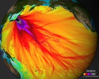
 Earth from Space: A gush of volcanic gas This image shows the huge plume of sulphur dioxide that spewed from Chile's Puyehue-Cordon Caulle Volcanic Complex, which lies in the Andes about 600 km south of Santiago. After lying dormant ... more | .. |
 US, Vietnam in joint call amid China tension The United States and Vietnam on Friday jointly called for freedom of navigation and rejected the use of force in the South China Sea, amid simmering tensions between Beijing and its neighbors. ... more | .. |
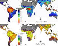 New NASA Map Reveals Tropical Forest Carbon Storage A NASA-led research team has used a variety of NASA satellite data to create the most precise map ever produced depicting the amount and location of carbon stored in Earth's tropical forests. The da ... more | .. |
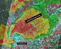 Satellite and Radar Data Reveal Damage Track of Alabama Tornadic Thunderstorms This image shows the radar reflectivity from the National Weather Service Doppler Radar in Birmingham, Ala. at 5:10 p.m. CDT on April 27, 2011, as a supercell thunderstorm moved across the city. ... more |
| .. |
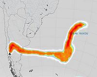
 Chilean Volcano Plume Moving Around the World Since its eruption in early June, several NASA satellites have captured images of the ash plume from the eruption of the Chilean Volcano called Puyehue-Cordon Caulle and have tracked it around the w ... more | .. |
 Japan's mega-quake struck in small zone of fault: study The deadly 9.0-magnitude quake that struck off northeastern Japan on March 11 ruptured a relatively small part of a notorious fault that straddles the Pacific seabed, Japanese scientists reported on Wednesday. ... more | .. |
 BU researcher plays key role in discovery of new type of neutrino oscillation The international T2K collaboration has announced that they have observed an indication of a new type of neutrino transformation or oscillation from a muon neutrino to an electron neutrino. Boston U ... more | .. |
 GMES operations another step closer Today, the European Commission has signed an agreement confirming the transfer of funds to ESA for the initial operations of the space component for the Global Monitoring for Environment and Securit ... more |
| Buy Advertising | Media Advertising Kit | Editorial & Other Enquiries | Privacy statement |
|
Free Newsletters - Delivered Daily Via Email - Space - War - Terra - Energy |
|
| .. |
 Temperature tracking device for packages may have climate metrology applications National Institute of Standards and Technology (NIST) researchers are working to reduce the uncertainty associated with climate-change measurements using a mobile temperature-sensing technology made ... more | .. |
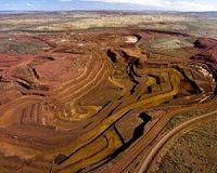 Rio Tinto to boost Pilbara iron ore Mining giant Rio Tinto will accelerate iron ore expansion in the Pilbara region of Western Australia with a $676 million investment, the company announced. ... more | .. |
 Scientists predict rare 'hibernation' of sunspots US scientists say the familiar sunspot cycle seems to be entering a hibernation period unseen since the 17th century, a pattern that could have a slight cooling effect on global temperatures. ... more | .. |
 Canadian Microbolometer Sensor Focusing on Oceans, Fires and Volcanoes Canada's Earth Observation Program reached new heights Friday with the successful launch of the 4th Argentinian Satelite de Aplicaciones Cientificas (SAC-D) aboard a Delta II rocket. The New I ... more |
| .. |
 Satellite maps useful to track habitat Satellite imagery can be used to quickly map indirect effects of the predator-prey relationship on the animals' habitats, an Australian researcher says. ... more | .. |
Scientists predict rare 'hibernation' of sunspots For years, scientists have been predicting the Sun would by around 2012 move into solar maximum, a period of intense flares and sunspot activity, but lately a curious calm has suggested quite the opposite. ... more | .. |
 Google applies for China mapping licence: report Google and its joint venture partner in China have applied for a licence to operate an online mapping service in the world's biggest web market, a report said Tuesday. ... more | .. |
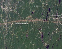 Landsat Satellite Images Compare Before and After Springfield Tornado Satellites provide a lot of useful information and the Landsat 5 satellite captured an image of the long damage track created on June 1, 2011 when a tornado tracked from Springfield to Sturbridge, M ... more |
| Buy Advertising | Media Advertising Kit | Editorial & Other Enquiries | Privacy statement |
|
Free Newsletters - Delivered Daily Via Email - Space - War - Terra - Energy |
|
| .. |
 NASA's infrared image of major Hurricane Adrian reveals its stormy life's blood Strong thunderstorms are the life's blood of tropical cyclones, and infrared and radar satellite data from NASA confirms that the eastern Pacific Ocean's first hurricane has plenty of them and they' ... more | .. |
 Age of Aquarius Dawns With California Launch NASA's 'Age of Aquarius' dawned Friday with the launch of an international satellite carrying the agency-built Aquarius instrument that will measure the saltiness of Earth's oceans to advance our un ... more | .. |
NASA launches ocean-watch satellite The US space agency on Friday launched a satellite to observe levels of salt on the surface of the world's oceans and measure how changes in salinity may be linked to future climate. ... more | .. |
 Helping shape space-based technology policies A Colorado State University professor known as an international expert in the use of GPS in agriculture has been named to a federal panel that helps shape national policy on space-based technologies ... more |
| .. |
 NASA ocean-watch satellite set for Friday launch The US space agency said it would attempt to launch on Friday a satellite to observe levels of salt on the surface of the world's oceans and how changes in salinity may be linked to future climate. ... more | .. |
 Hot Towers in First Tropical Depression of the Eastern Pacific The Tropical Rainfall Measuring Mission satellite called TRMM has the ability to see rainfall rates and heights of thunderstorm clouds within a tropical cyclone, and data from the satellite confirme ... more | .. |
Aquarius to Study the Power of Sea Salt A new observatory is about to leave Earth to map a powerful compound of global importance: Common everyday sea salt. Researchers suspect that the salinity of Earth's oceans has far-reaching effects ... more | .. |
 NASA Goes Below the Surface to Understand Salinity When NASA's Aquarius mission launches this week, its radiometer instruments will take a "skin" reading of the oceans' salt content at the surface. From these data of salinity in the top 0.4 inch (1 ... more |
| Previous Issues | Jun 20 | Jun 17 | Jun 16 | Jun 15 | Jun 14 |
| The contents herein, unless otherwise known to be public domain, are Copyright 1995-2011 - SpaceDaily. AFP and UPI Wire Stories are copyright Agence France-Presse and United Press International. ESA Portal Reports are copyright European Space Agency. All NASA sourced material is public domain. Additional copyrights may apply in whole or part to other bona fide parties. Advertising does not imply endorsement, agreement or approval of any opinions, statements or information provided by SpaceDaily on any web page published or hosted by SpaceDaily. Privacy statement |
|
Free Newsletters - Delivered Daily Via Email - Space - War - Terra - Energy |
| Buy Advertising | Media Advertising Kit | Editorial & Other Enquiries | Privacy statement |


