|
|
 Landsat Satellite Images Compare Before and After Springfield Tornado
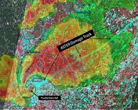
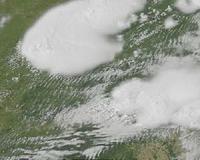
Greenbelt MD (SPX) Jun 14, 2011 Satellites provide a lot of useful information and the Landsat 5 satellite captured an image of the long damage track created on June 1, 2011 when a tornado tracked from Springfield to Sturbridge, Mass. An earlier image is now available from 2010 that enables people to more clearly see the damage path the June 2011 twister created on its eastward track. A Landsat 5 satellite image from October 8, 2010 has been released from NASA and the U.S. Geological Survey that shows the area between Springfiel ... read more |
. |

|
| Buy Advertising | Media Advertising Kit | Editorial & Other Enquiries | Privacy statement |
|
Free Newsletters - Delivered Daily Via Email - Space - War - Terra - Energy |
| .. |
 Canadian Microbolometer Sensor Focusing on Oceans, Fires and Volcanoes Canada's Earth Observation Program reached new heights Friday with the successful launch of the 4th Argentinian Satelite de Aplicaciones Cientificas (SAC-D) aboard a Delta II rocket. The New I ... more | .. |
 Age of Aquarius Dawns With California Launch NASA's 'Age of Aquarius' dawned Friday with the launch of an international satellite carrying the agency-built Aquarius instrument that will measure the saltiness of Earth's oceans to advance our un ... more | .. |
 Temperature tracking device for packages may have climate metrology applications National Institute of Standards and Technology (NIST) researchers are working to reduce the uncertainty associated with climate-change measurements using a mobile temperature-sensing technology made ... more | .. | ||
| .. |
 Scientists predict rare 'hibernation' of sunspots For years, scientists have been predicting the Sun would by around 2012 move into solar maximum, a period of intense flares and sunspot activity, but lately a curious calm has suggested quite the opposite. ... more | .. |
 Google applies for China mapping licence: report Google and its joint venture partner in China have applied for a licence to operate an online mapping service in the world's biggest web market, a report said Tuesday. ... more | .. |
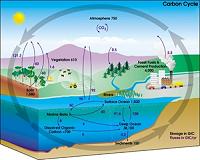
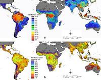 New NASA Map Reveals Tropical Forest Carbon Storage A NASA-led research team has used a variety of NASA satellite data to create the most precise map ever produced depicting the amount and location of carbon stored in Earth's tropical forests. The da ... more | .. |
 Satellite and Radar Data Reveal Damage Track of Alabama Tornadic Thunderstorms This image shows the radar reflectivity from the National Weather Service Doppler Radar in Birmingham, Ala. at 5:10 p.m. CDT on April 27, 2011, as a supercell thunderstorm moved across the city. ... more |
|
Free Newsletters - Delivered Daily Via Email - Space - War - Terra - Energy |
| . | . |
|
| .. |
 NASA's infrared image of major Hurricane Adrian reveals its stormy life's blood Strong thunderstorms are the life's blood of tropical cyclones, and infrared and radar satellite data from NASA confirms that the eastern Pacific Ocean's first hurricane has plenty of them and they' ... more | .. |
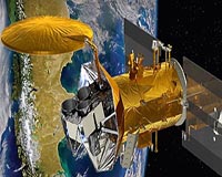
NASA launches ocean-watch satellite The US space agency on Friday launched a satellite to observe levels of salt on the surface of the world's oceans and measure how changes in salinity may be linked to future climate. ... more | .. |
 Helping shape space-based technology policies A Colorado State University professor known as an international expert in the use of GPS in agriculture has been named to a federal panel that helps shape national policy on space-based technologies ... more | .. |
 NASA ocean-watch satellite set for Friday launch The US space agency said it would attempt to launch on Friday a satellite to observe levels of salt on the surface of the world's oceans and how changes in salinity may be linked to future climate. ... more |
| .. |
 Hot Towers in First Tropical Depression of the Eastern Pacific The Tropical Rainfall Measuring Mission satellite called TRMM has the ability to see rainfall rates and heights of thunderstorm clouds within a tropical cyclone, and data from the satellite confirme ... more | .. |
Aquarius to Study the Power of Sea Salt A new observatory is about to leave Earth to map a powerful compound of global importance: Common everyday sea salt. Researchers suspect that the salinity of Earth's oceans has far-reaching effects ... more | .. |
 NASA Goes Below the Surface to Understand Salinity When NASA's Aquarius mission launches this week, its radiometer instruments will take a "skin" reading of the oceans' salt content at the surface. From these data of salinity in the top 0.4 inch (1 ... more | .. |
GPS Stations Can Detect Clandestine Nuclear Tests At the Comprehensive Nuclear-Test-Ban Treaty Organization (CTBTO) meeting this week, American researchers are unveiling a new tool for detecting illegal nuclear explosions: the Earth's global positi ... more |
| Buy Advertising | Media Advertising Kit | Editorial & Other Enquiries | Privacy statement |
|
Free Newsletters - Delivered Daily Via Email - Space - War - Terra - Energy |
|
| .. |
 Three Satellites See Eruption of Puyehue-Cordon Volcano from Space NASA's Terra Satellite, the GOES-13 and GOES-11 satellites all captured images of the ash plume from southern Chile's Puyehue-Cordon Volcano this week. The volcano is located in Puyehue National Par ... more | .. |
 Industry Helps Engineering Students Reanimate Robotic Mine Vehicles In just 10 weeks, a group of University of Arizona engineering students took five crates of surplus hardware and two heavy-duty test vehicles, which didn't run, and mixed them with youthful enthusia ... more | .. |
 Russia plans to launch six Glonass satellites in 2011 Russian Space Agency Roscosmos plans to launch five Glonass-M satellites and one Glonass-K satellite in 2011, Roscosmos' deputy chief Anatoly Shilov said Wednesday. The first launch of the Glo ... more | .. |
 Workshop Preps Educators to Train Next-Gen Carbon Researchers A group of science educators stand outside on a sunny day at NASA's Langley Research Center and listen to Sarah Silverberg, a GLOBE project coordinator and trainer, talk about the parts of a compass ... more |
| .. |
 India plans to make GPS more accurate with GAGAN The GPS Aided Geo Augmented Navigation or GPS and Geo Augmented Navigation system (GAGAN) is a planned implementation of a regional Satellite Based Augmentation System (SBAS) by the Indian governmen ... more | .. |
 New NASA Salt Mapper to Spice Up Climate Forecasts Salt is essential to human life. Most people don't know, however, that salt - in a form nearly the same as the simple table variety - is just as essential to Earth's ocean, serving as a critical dri ... more | .. |
 Rare tiger killed in Nepal A rare wild tiger, nursed back to health by Nepalese vets after being injured, has been killed by poachers, a wildlife official said on Friday. ... more | .. |
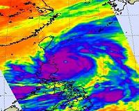 NASA sees a 14-mile-wide eye and powerful Super Typhoon Songda Typhoon Songda became a Super Typhoon in the evening on May 26, 2011 (Eastern Daylight Time) was it reached a Category 5 status on the Saffir-Simpson Scale. NASA satellite data shows that the monste ... more |
| Buy Advertising | Media Advertising Kit | Editorial & Other Enquiries | Privacy statement |
|
Free Newsletters - Delivered Daily Via Email - Space - War - Terra - Energy |
|
| .. |
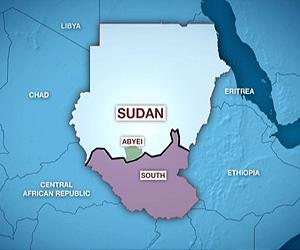 Foreign NGO says satellite images indicate war crimes in Sudan's Abyei An international non- governmental organization monitoring Sudanese air space on Wednesday said satellite photos showed evidence of war crimes committed at Sudan's disputed oil-rich area of Abyei, w ... more | .. |
 For Aquarius, Sampling Seas No 'Grain of Salt' Task The breakthrough moment for oceanographer Gary Lagerloef, the principal investigator for NASA's new Aquarius mission, came in 1991. That's when he knew it would be possible to make precise measureme ... more | .. |
 Satellite observations show potential to improve ash cloud forecasts Predicting the exact dispersal of a volcanic ash cloud is never going to be easy. However, satellite data are showing that the eruption from Iceland's Grimsvotn volcano this week was unlikely to hav ... more | .. |
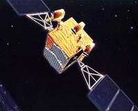
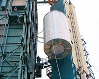
 Success of GSAT-8 and Future of India's Space Programme India's advanced communication geostationary satellite, GSAT-8, was successfully launched on May 21, 2011. The satellite was put in orbit from French Guiana by the Ariane-V launch vehicle. Indian Sp ... more |
| .. |
 NASA satellite helps find 17 Egypt pyramids Archaeologists have uncovered as many as 17 buried pyramids in Egypt with the help of NASA satellite imagery, according to a documentary to be aired by the BBC on Monday. ... more | .. |
GMES Masters seeks innovative uses for Earth observation data Bavarian Minister of Economic Affairs Martin Zeil joined with ESA Director General Jean-Jacques Dordain in launching the GMES Masters competition, seeking out innovative commercial uses of Earth obs ... more | .. |
 GOES-13 Satellite Video Close-Up of Deadly Joplin, Missouri Tornado The Geostationary Operational Environmental Satellite called GOES-13 provides forecasters with continuous visible and infrared imagery of weather systems across the U.S. and a new movie from the NAS ... more | .. |
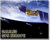 EU to launch Galileo satellites this fall Backed by Russia, the Europeans will launch two of their Galileo global positioning satellites into space in October, the European Commission said this week. ... more |
| Previous Issues | Jun 14 | Jun 13 | Jun 10 | Jun 09 | Jun 08 |
| The contents herein, unless otherwise known to be public domain, are Copyright 1995-2011 - SpaceDaily. AFP and UPI Wire Stories are copyright Agence France-Presse and United Press International. ESA Portal Reports are copyright European Space Agency. All NASA sourced material is public domain. Additional copyrights may apply in whole or part to other bona fide parties. Advertising does not imply endorsement, agreement or approval of any opinions, statements or information provided by SpaceDaily on any web page published or hosted by SpaceDaily. Privacy statement |
|
Free Newsletters - Delivered Daily Via Email - Space - War - Terra - Energy |
| Buy Advertising | Media Advertising Kit | Editorial & Other Enquiries | Privacy statement |


