|
|
Paris, France (ESA) Oct 16, 2009 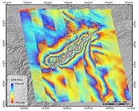 Using satellite radar data and GPS measurements, Chinese researchers have explained the exceptional geological events leading to the 2008 Wenchuan Earthquake that killed nearly 90 000 people in China's Sichuan Province. "One of the very fundamental issues for understanding an earthquake is to know how the rupture is distributed on the fault plane, which is directly related to the amount of ... read more
 Redlands CA (SPX) Oct 14, 2009
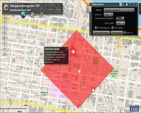
Philadelphia Police Department (PPD) in Pennsylvania uses an advanced enterprise geographic information system (GIS) platform that gives staff the ability to analyze millions of records and make better decisions. GIS applications allow officers to accurately map crime rates and patterns and ultimately make more arrests. "GIS gives us a platform to build from," says Michael Urciuoli, GIS ... more
|
| |||||||||||||||
| Previous Issues | Oct 15 | Oct 14 | Oct 13 | Oct 12 | Oct 09 |
| . |
 La Jolla CA (SPX) Oct 14, 2009
Blue Sky Network has announced Nigerian-based Max Air selected Blue Sky Network's automated flight following and communication devices for its fleet of planes. Max Air will particularly depend on this safety equipment in late November during the Hajj, an annual Muslim pilgrimage to the Islamic Holy Land that has traditionally been plagued with travel difficulties. To ensure safe and timely ... more  Moscow, Russia (RIA Novosti) Oct 14, 2009
Russia is planning to orbit three Glonass navigation satellites on October 29 following their launch cancellation in September, the Federal Space Agency Roscosmos said on Monday. The planned September 25 launch of Glonass satellites from the Bikonur space center in Kazakhstan has been moved back by over a month due to a technical defect in one of the satellites. "This launch is in ... more  Dearborn MI (SPX) Oct 13, 2009
Researchers have found potential for a GPS satellite to act as an early warning system that detects when a vehicle is about to lose control and communicate with the vehicle's stability control systems and other safety features to prevent a rollover or other serious accident. The research findings will be presented next week at the Institute of Electrical and Electronics ... more |
. |
|
|
. |
 Pasadena CA (SPX) Oct 06, 2009
NASA's Mars Exploration Rover Opportunity has found a rock that apparently is another meteorite, less than three weeks after driving away from a larger meteorite that the rover examined for six weeks. Opportunity used its navigation camera during the mission's 2,022nd Martian day, or sol, (Oct. 1, 2009) to take this image of the apparent meteorite dubbed "Shelter Island." The pitted ... more Mr Antonio Tajani, European Commission Vice-President for Transport Policy, has announced the official start of operations for EGNOS, the European Geostationary Navigation Overlay Service. The EGNOS 'Open Service' is now available. This is a major milestone for the project: its primary service is now available to all users equipped with EGNOS-compatible receivers. Most mass-market satellite ... more  London, UK (SPX) Oct 02, 2009
Surrey Satellite Technology Ltd (SSTL) has successfully completed the planned repositioning of the first Galileo test satellite, GIOVE-A, to a higher orbit to make way for the operational satellites of Europe's satellite navigation constellation. From the GIOVE-A operational headquarters in Guildford, UK, SSTL's operating team executed a series of precisely planned manoeuvres during July ... more |
. |
| Previous Issues | Oct 15 | Oct 14 | Oct 13 | Oct 12 | Oct 09 |
| The contents herein, unless otherwise known to be public domain, are Copyright 1995-2009 - SpaceDaily. AFP and UPI Wire Stories are copyright Agence France-Presse and United Press International. ESA Portal Reports are copyright European Space Agency. All NASA sourced material is public domain. Additional copyrights may apply in whole or part to other bona fide parties. Advertising does not imply endorsement, agreement or approval of any opinions, statements or information provided by SpaceDaily on any web page published or hosted by SpaceDaily. Privacy statement |