|
|
Redlands CA (SPX) Oct 13, 2009 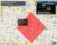 The Virginia Department of Emergency Management (VDEM) recently launched the Virginia Interoperability Picture for Emergency Response (VIPER) using enterprise geographic information system (GIS) software from ESRI. In addition to providing a Web-based common operating picture and analysis tools, VIPER integrates with numerous information systems and links with approximately 250 data feeds. ... read more
 San Antonio TX (SPX) Oct 13, 2009
DigitalGlobe's recently launched WorldView-2 satellite provides an unprecedented level of detail and geospatial accuracy for imaging and mapping the Earth's surface. Operating at an altitude of 770 kilometers, WorldView-2 features an advanced onboard imaging system with better than 0.5-meter panoramic resolution and 1.8-meter multispectral resolution and is capable of collecting images of up to ... more
|
| |||||||||||||||
| Previous Issues | Oct 12 | Oct 09 | Oct 08 | Oct 07 | Oct 06 |
| . |
 Dearborn MI (SPX) Oct 13, 2009
Researchers have found potential for a GPS satellite to act as an early warning system that detects when a vehicle is about to lose control and communicate with the vehicle's stability control systems and other safety features to prevent a rollover or other serious accident. The research findings will be presented next week at the Institute of Electrical and Electronics ... more CSR has introduced the SiRFstarIV GSD4e GPS location processor, the newest member of the recently launched SiRFstarIV architecture, an innovation that promises to redefine the meaning of "location awareness" for mobile devices. Building upon the SiRFstarIV architecture's high-performance and micro-power capabilities, the GSD4e adds a built-in CPU and innovations such as SiRFGeoRecov ... more  St. Louis MO (SPX) Oct 13, 2009
Boeing has signed Foreign Military Sales (FMS) contracts with the U.S. government to provide Laser Joint Direct Attack Munitions (JDAM) to two international customers. The FMS contracts are part of a $98 million indefinite delivery, indefinite quantity contract for Laser JDAM production and integration that Boeing received in August. The weapons are scheduled for delivery in 2010. ... more |
. |
|
|
. |
 Herndon VA (SPX) Oct 02, 2009
Northrop Grumman has equipped and fielded its Hunter Unmanned Aircraft System (UAS) with an Automatic Takeoff and Landing System (ATLS) to the Army's UAS Training Battalion, Fort Huachuca, Ariz., where it successfully completed its first launch and recovery. Hunter, which has been in use with the Army since 1996, was originally designed using an External Pilot (EP) for take-offs and ... more  Redlands CA (SPX) Oct 01, 2009
The Eugene Police Department (EPD) in Oregon has transformed how it takes advantage of maps and related data throughout the agency, deploying powerful desktop and Web geographic information systems (GIS) to more effectively carry out law enforcement tasks. EPD links its records management data, computer-aided dispatch data, and information from other sources to an easily shared information ... more Boeing has completed developmental system testing on the U.S. Air Force's Global Positioning System (GPS) satellite ground control system, known as the Operational Control Segment (OCS), for the addition of a critical new security capability. The test demonstrated that the Selective Availability Anti-Spoofing Module (SAASM) software upgrade meets all contractual system requirements. SAASM ... more |
. |
| Previous Issues | Oct 12 | Oct 09 | Oct 08 | Oct 07 | Oct 06 |
| The contents herein, unless otherwise known to be public domain, are Copyright 1995-2009 - SpaceDaily. AFP and UPI Wire Stories are copyright Agence France-Presse and United Press International. ESA Portal Reports are copyright European Space Agency. All NASA sourced material is public domain. Additional copyrights may apply in whole or part to other bona fide parties. Advertising does not imply endorsement, agreement or approval of any opinions, statements or information provided by SpaceDaily on any web page published or hosted by SpaceDaily. Privacy statement |