 |
Atlanta GA (SPX) Jul 13, 2010 EMS Aviation has announced that its FLEET tracking system is being used by Florida-based Heliworks Inc. to help rescue birds endangered by the oil spill in the Gulf of Mexico. Contracted by the U.S. Fish and Wildlife Service to search for affected birds and lead rescuers to their locations, Heliworks operates Bell 206Ls equipped with the EMS Aviation FLEET tracking system. The helicopters fly biologists low and close to the coastline to locate oil-covered birds while the U.S. Fish and Wildlife Service monitors the Internet-based Automated Flight Following (AFF) map. The map shows officials the helicopter's geographical location, speed, heading, altitude, and flight history. "When a biologist spots a bird, FLEET Tracker ensures that the U.S. Fish and Wildlife Service knows our exact location," says Richard Simpson, vice president of Heliworks. "This helps operations determine where to send ground crews. And that means they can locate and rescue the oiled birds more quickly." Although EMS' FLEET system also offers text and phone services for flight crews and passengers on board, its most important functionality for this unique rescue mission is automated tracking. This capability lets the pilot focus on flying and helps the U.S. Fish and Wildlife Service get ground crews in place more rapidly. "We are extremely proud to see our systems being used to rescue birds in the sensitive Gulf environment," said Nim Evatt, vice president and general manager of EMS Aviation. "This is an example of using commercial know-how to take technology beyond its traditional field of use for an important and worthwhile cause." Heliworks has seven aircraft equipped with EMS Aviation's FLEET Tracker system, which includes an Iridium antenna and transceiver with integrated GPS for flight following and a Mission Management Unit (MMU) for fast two-way text messaging, and phone services.
Share This Article With Planet Earth
Related Links EMS Aviation GPS Applications, Technology and Suppliers
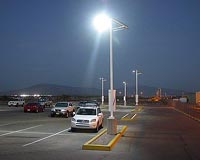 New System Helps Locate Car Park Spaces
Barcelona, Spain (SPX) Jul 09, 2010 A research group from the UAB Department of Telecommunications and Systems Engineering at the School of Engineering, led by Jose Lopez Vicario and Antoni Morell, took part in the development of a new system which locates unoccupied car park spaces and guides users to the nearest one. The new network of sensors for the management of public car parks and locations, which researchers have nam ... read more |
|
| The content herein, unless otherwise known to be public domain, are Copyright 1995-2010 - SpaceDaily. AFP and UPI Wire Stories are copyright Agence France-Presse and United Press International. ESA Portal Reports are copyright European Space Agency. All NASA sourced material is public domain. Additional copyrights may apply in whole or part to other bona fide parties. Advertising does not imply endorsement,agreement or approval of any opinions, statements or information provided by SpaceDaily on any Web page published or hosted by SpaceDaily. Privacy Statement |


 del.icio.us
 Digg
Digg Reddit
 YahooMyWeb
 Google