|
New York NY (SPX) Nov 24, 2008 Younger and older Americans use GPS devices differently, according to a recent survey of US consumers conducted by ABI Research. "When younger GPS users are compared to their older counterparts, there's clearly an age divide not only in what types of devices they use, but in how they use them," says ABI Research director Janet Wise. The online survey, which was conducted in August 2008 and included responses from 750 in-car navigation users, was focused on navigation form factors, use cases, navigation feature usage, and brand satisfaction. Among the age-related differences observed: + While portable navigation devices (PNDs) are, across all ages, the most commonly-used type of navigation device, mobile phones or PDAs with navigation service are much more likely to be used by those under age 35. + Significantly higher percentages of those under age 45 use one- or two-way connected PNDs. + Significantly higher percents of younger users download location-based search and traffic information. "With navigation solutions quickly spreading to all age groups in society, it becomes increasingly important for navigation vendors to offer products which address the different needs of the different age segments," adds ABI Research director Dominique Bonte. "While younger age groups are willing to adopt new connected navigation form factors and services, older groups clearly prefer no-frills, affordable, easy to use, 'working out of the box' non-connected PNDs." Related Links Consumer Navigation Survey Findings GPS Applications, Technology and Suppliers
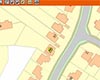 London, UK (SPX) Nov 24, 2008
Infoterra has partnered with Stanfords Business Mapping, a leading retail supplier of paper mapping and map data for businesses, to develop a cost-effective new geographical asset management system - Stanfords GIS - for organisations managing property portfolios. This new system incorporates mapping and aerial photography in a secure, web-based management interface to provide an integrated geographical property database. |
|
| The content herein, unless otherwise known to be public domain, are Copyright Space.TV Corporation. AFP and UPI Wire Stories are copyright Agence France-Presse and United Press International. ESA Portal Reports are copyright European Space Agency. All NASA sourced material is public domain. Additional copyrights may apply in whole or part to other bona fide parties. Advertising does not imply endorsement, agreement or approval of any opinions, statements or information provided by Space.TV Corp on any Web page published or hosted by Space.TV Corp. Privacy Statement |