|
Greenbelt MD (SPX) Nov 21, 2007 Earth: water planet. Oceans, rivers, aquifers, rain: these and many other features describe the hydrologic anatomy of Earth's thin, life-supporting layers of upper crust and lower atmosphere. How it works-that is, how water circulates, behaves, and interacts is much harder to determine. That's why there's TRMM, and this year NASA celebrates the tenth anniversary of this one-of-a-kind spacecraft. Built in cooperation with the Japanese Space agency JAXA, The Tropical Rainfall Measuring Mission has helped scientists re-write the book about profound parts of Earth's water cycle.
Global Rainfall Distribution
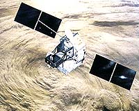
The TRMM Spacecraft The satellite uses several instruments to detect rainfall including radar, microwave imaging, and lightning sensors. Flying at a low orbital altitude of 240 miles (400 kilometers) TRMM's data collection of tropical precipitation helps improve our understanding about climate and weather. The Japanese space agency (JAXA) launched the satellite on an H-II rocket from Tanegashima Space Center on November 27, 1997.
TRMM-Goddard Legacy of Excellence While most other research spacecraft are the direct work of designated contractors or other outside parties, civil servant engineers at NASA Goddard directed the completion and constructed the spacecraft almost entirely in-house. They also completed the integration of all the scientific instruments onboard. But prior to the assembly phase, TRMM's legacy extends far back in Goddard's history. The idea for a space based precipitation observatory like TRMM comes from the work of three Goddard scientists. Their initial blue-sky idea turned into formal project proposals, which in turn transformed into actual development plans, build specifications, flight hardware, and, ultimately, operational science platforms on orbit performing far beyond anyone's expectations. Goddard maintains the TRMM data archive, and processes most of the information the satellite sends back to Earth. The center also conducts most of the primary science research based on TRMM data. TRMM based research also serves as a signpost for the future. Soon the science team will be phasing in a new means for analyzing data. Called the PPS, or Precipitation Processing System, this new methodology will help leverage TRMM data against other space based earth observing instruments in order to broaden the range of possibilities for studying precipitation from above. It will also become the processing plan for the upcoming GPM (Global Precipitation Measurement) mission. So even though the hardware and even personnel may change and evolve, the benefits of Goddard's deep legacy with TRMM will continue to carry forward. Related Links TRMM Animation Earth Observation News - Suppiliers, Technology and Application
 Paris, France (SPX) Nov 16, 2007
This striking composite of Earth by night shows the illuminated crescent over Antarctica and cities of the northern hemisphere. The images were acquired with the OSIRIS Wide Angle Camera (WAC) during Rosetta's second Earth swing-by on 13 November. This image showing islands of light created by human habitation was taken with the OSIRIS WAC at 19:45 CET, about 2 hours before the closest approach of the spacecraft to Earth. |
|
| The content herein, unless otherwise known to be public domain, are Copyright Space.TV Corporation. AFP and UPI Wire Stories are copyright Agence France-Presse and United Press International. ESA Portal Reports are copyright European Space Agency. All NASA sourced material is public domain. Additional copyrights may apply in whole or part to other bona fide parties. Advertising does not imply endorsement, agreement or approval of any opinions, statements or information provided by Space.TV Corp on any Web page published or hosted by Space.TV Corp. Privacy Statement |