|
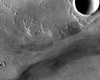
Tempe, AZ (SPX) Jun 08, 2007 The Thermal Emission Imaging System (THEMIS) aboard NASA's Mars Odyssey orbiter marked a milestone May 4. An image from THEMIS showing Martian lava flows and wind streaks mingling with impact craters, became the 1,200th "Image of the Day" posted online. The Mars Space Flight Facility at ASU operates the site, which is updated every weekday with images and data from THEMIS. The first "Image of the Day" was posted March 27, 2002. "We usually select the 'Image of the Day' to show the wide variety of surface features present on Mars," says Kelly Bender, THEMIS mission planner. "Some images, however, are chosen purely for their aesthetic value." THEMIS is a multiple-wavelength camera that photographs the Martian surface in five visual and 10 infrared bands. At infrared wavelengths, the smallest details it records are 330 feet (100 meters) wide, while at visual wavelengths - as seen in the image - the smallest details are 60 feet (18 meters) wide. Image of the day No. 1,200 shows a strip of ground on Mars that measures 11 miles (18 kilometers) wide by 39 miles (63 kilometers) long. "We're looking at the Daedalia Planum region, part of the large volcanic province of Tharsis," Bender says. "The lava flows came from the Arsia Mons volcano. Its summit lies about 300 miles, or 500 kilometers, beyond the image frame to the right. The rough textured lava surface traps dust and sand, while the impact craters act as obstacles to the wind." She notes that the combination of readily available dust and turbulent winds passing the craters creates the bright and dark "tails" extending the west (left) of the craters. "These wind streaks indicate the direction the wind was blowing - east to west in this case," she says. "From the very beginning of the THEMIS project, I wanted to bring Mars alive for everyone," says Philip Christensen, Regents' Professor of geological sciences in the School of Earth and Space Exploration, part of ASU's College of Liberal Arts and Sciences. "One of the most enjoyable ways has been to post a new image each day of the mission with a brief description of what we think we are looking at." Christensen is the director of the Mars Space Flight Facility, and both designer and principal investigator for the THEMIS instrument. "Many features we see in these images remain a mystery," he says. "More often than not, we scratch our heads and mutter, 'Wow, what's that?' But that's the fun of exploring Mars, and hopefully those who follow the mission through our images can share in the experience of looking at the unknown for the first time." THEMIS images are available online at http://themis-data.asu.edu/, where users can search for images by designation or using a map of Mars. Each image is accompanied by data on when the image was taken, where the spacecraft was pointing, the resolution of the image, the local time and so on. Images can be downloaded in PNG, JPEG, GIF or TIFF formats. Image of the day No. 1,200 carries the identification designation V23407003. Mars Odyssey was launched from the Kennedy Space Center in Florida on April 7, 2001, and arrived at Mars on Oct. 24, 2001. The orbiter spent the next several months achieving a circular mapping orbit by aerobraking (dipping into the atmosphere to slow and shrink the orbit). Aerobraking concluded in early February 2002, and primary mapping operations began a few weeks later. Related Links THEMIS images Database Mars Odyssey Mars News and Information at MarsDaily.com Lunar Dreams and more
 Pasadena CA (SPX) May 03, 2007
Color coding in this map of a far-southern site on Mars indicates the change in nighttime ground-surface temperature between summer and fall. This site, like most of high-latitude Mars, has water ice mixed with soil near the surface. The ice is probably in a rock-hard frozen layer beneath a few centimeters or inches of looser, dry soil. The amount of temperature change at the surface likely corresponds to how close to the surface the icy material lies. |
|
| The content herein, unless otherwise known to be public domain, are Copyright Space.TV Corporation. AFP and UPI Wire Stories are copyright Agence France-Presse and United Press International. ESA Portal Reports are copyright European Space Agency. All NASA sourced material is public domain. Additional copyrights may apply in whole or part to other bona fide parties. Advertising does not imply endorsement, agreement or approval of any opinions, statements or information provided by Space.TV Corp on any Web page published or hosted by Space.TV Corp. Privacy Statement |