 |
Canberra, Australia (SPX) Mar 06, 2007 Nearly 200 ocean and climate scientists will gather in Hobart this month for the first meeting in the Southern Hemisphere of the NASA/French Space Agency Ocean Surface Topography Science Team. The scientists specialise in using satellite altimeters to:
+ monitor and understand global sea level rise Meeting Convenor, Dr David Griffin from CSIRO's Wealth from Oceans National Research Flagship, says data from the satellites, TOPEX-Poseidon and Jason-1 (both managed jointly by NASA and the French space agency, CNES), has dramatically changed scientists' understanding of ocean dynamics. "The development and application of satellite altimeters over the past 15 years has generated many new insights into climate dynamics and ocean physics," Dr Griffin says. "By monitoring sea level variations, we can tell which way surface currents are flowing, as well as what is happening beneath the surface such as upwellings of cold water from the oceans' depths." CSIRO Marine and Atmospheric Research and Antarctic Climate and Ecosystem Cooperative Research Centre (ACECRC) scientist, Dr John Church, will present one of the opening presentations of science results. "The rate of global sea level rise measured by the altimeters is at the upper limit of the rate predicted by computer models developing scenarios of climate change," Dr Church says. CSIRO, through the Wealth from Oceans Research Flagship, the Royal Australian Navy and the Bureau of Meteorology, is one of the sponsors of the meeting, which runs from March 12-15. The most recent local applications include forecasting for bluewater ocean races such as the Rolex Sydney to Hobart race and explanation of dramatically changing water temperatures off the NSW coast. Dr Griffin says Tasmania has many close links to the ocean surface topography science community involving scientists at institutions such as: CSIRO, the Australian Government Antarctic Division, the ACECRC, the University of Tasmania and the Bureau of Meteorology. An additional local link is that Bass Strait is one of only three locations around the world where the accuracy of the satellite instruments is continually checked against instruments at Burnie. Related Links CSIRO Making money out of watching earth from space today Earth Observation News - Suppiliers, Technology and Application
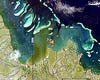 Canberra, Australia (SPX) Feb 28, 2007
A stunning series of satellite imagery of Australia's Great Barrier Reef released by the CSIRO shows for the first time visual confirmation of the theory that sediment plumes travel to the outer reef, and beyond. |
|
| The content herein, unless otherwise known to be public domain, are Copyright Space.TV Corporation. AFP and UPI Wire Stories are copyright Agence France-Presse and United Press International. ESA Portal Reports are copyright European Space Agency. All NASA sourced material is public domain. Additional copyrights may apply in whole or part to other bona fide parties. Advertising does not imply endorsement, agreement or approval of any opinions, statements or information provided by Space.TV Corp on any Web page published or hosted by Space.TV Corp. Privacy Statement |

