 |
Reston VA (SPX) Apr 07, 2010 Raytheon was awarded a NASA Goddard contract to maintain and manage large volumes of sensing data and imagery from space instruments. The Earth Observing System Data and Information System (EOSDIS) evolution and development contract will give climate researchers access to valuable data about the earth's atmospheres, oceans, lands and their interactions. The evolution and development program, an indefinite-delivery, indefinite-quantity cost plus award fee contract, will have a $250 million ceiling for the five-year base period of performance and an initial value of $75 million. "This contract enables Raytheon to continue to build upon our strong legacy of providing program excellence, innovation and reliable engineering solutions to NASA's earth observing systems," said TW Scott, vice president of Raytheon's Mission Operations and Solutions. "We look forward to supporting the EOSDIS evolution and ensuring that NASA Goddard's earth sensing data and imagery are available to educators, scientists, researchers and policy makers." Raytheon developed the core components of EOSDIS, called the EOSDIS core system, which became operational in 1999; it provides data ingest, archive and distribution services at data centers that manage earth observing data. In 2003, Raytheon won the core system maintenance and development contract and has continued its partnership with NASA to maintain and evolve key elements of EOSDIS. NASA developed EOSDIS to manage and provide access to data collected by a suite of earth observation satellites. This data is used by a growing international user community that includes earth scientists, educators, federal, state, local and tribal agencies, and the public. The data has many uses, including climate change research, disaster planning and response, natural resource assessment, and understanding the earth as an integrated system.
Share This Article With Planet Earth
Related Links Raytheon Earth Observation News - Suppiliers, Technology and Application
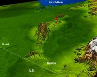 Topography Reflects Baja Quake Site's Complex Geology
Pasadena CA (JPL) Apr 07, 2010 The topography surrounding the Laguna Salada fault in the Mexican state of Baja, California, is clearly shown in this combined radar image and topographic view (above) generated with data from NASA's Shuttle Radar Topography Mission (SRTM). On April 4, 2010, a magnitude 7.2 earthquake struck along this fault about 64 kilometers (40 miles) south of the Mexico-United States border. Acc ... read more |
|
| The content herein, unless otherwise known to be public domain, are Copyright 1995-2010 - SpaceDaily. AFP and UPI Wire Stories are copyright Agence France-Presse and United Press International. ESA Portal Reports are copyright European Space Agency. All NASA sourced material is public domain. Additional copyrights may apply in whole or part to other bona fide parties. Advertising does not imply endorsement,agreement or approval of any opinions, statements or information provided by SpaceDaily on any Web page published or hosted by SpaceDaily. Privacy Statement |


 del.icio.us
 Digg
Digg Reddit
 YahooMyWeb
 Google