|
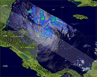
Greenbelt MD (SPX) Nov 07, 2008 A hurricane watch has been posted for the Cayman Islands. A Hurricane watch means that hurricane conditions are possible within the watch area...generally within 36 hours. At 1 p.m. EST, Nov. 6, Tropical Storm Paloma, located in the western Caribbean near the Honduras/Nicaragua border, has continued to strengthen. Paloma's maximum sustained winds have increased to near 60 mph with higher gusts. Steady strengthening is forecast during the next couple of days and Paloma could become a hurricane tonight or tomorrow. Paloma was near latitude 15.9 north and longitude 81.9 west or about 105 miles northeast of Cabo Gracias a Dios on the Nicaragua/Honduras border and about 235 miles south of Grand Cayman. Paloma is moving toward the north near 7 mph...11 km/hr. This general motion is expected today with a gradual turn toward the Northeast forecast late on Friday or on Saturday. Minimum central pressure is now 997 millibars. The image above shows a rainfall analysis of tropical storm Paloma using data from the Tropical Rainfall Measuring Mission (TRMM) satellite as it passed above on November 6 at 1341 UTC (8:41 AM EST). At that time Paloma was increasing in strength with wind speeds between 35 to 40 knots (40 to 46 miles per hour). Paloma was already a well organized storm with precipitation particularly heavy in a feeder band in Paloma's southwest quadrant. The center of Paloma's circulation was clearly revealed by TRMM's Precipitation Radar (PR) instrument. TRMM can gauge the rainfall generated by a storm. Paloma is expected to produce total rainfall accumulations of 2 to 4 inches over eastern Honduras and northeastern Nicaragua. Four to eight inches of rain over the Cayman Islands is expected with isolated maximum totals of 12 inches possible. Tropical Storm Paloma formed in the Caribbean Sea northeast of Nicaragua on the morning of 6 November 2008. Paloma is predicted by the National Hurricane Center to intensify as it moves through the Caribbean and possibly become a category 2 hurricane before hitting central Cuba in the next three or four days. Related Links Goddard Space Flight Center Earth Observation News - Suppiliers, Technology and Application
 Greenbelt MD (SPX) Nov 07, 2008
A NASA-led research team has used satellite data to make the most precise measurements to date of changes in the mass of mountain glaciers in the Gulf of Alaska, a region expected to be a significant contributor to global sea level rise over the next 50-100 years. |
|
| The content herein, unless otherwise known to be public domain, are Copyright Space.TV Corporation. AFP and UPI Wire Stories are copyright Agence France-Presse and United Press International. ESA Portal Reports are copyright European Space Agency. All NASA sourced material is public domain. Additional copyrights may apply in whole or part to other bona fide parties. Advertising does not imply endorsement, agreement or approval of any opinions, statements or information provided by Space.TV Corp on any Web page published or hosted by Space.TV Corp. Privacy Statement |