|
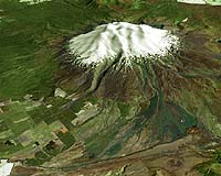
Wellington (AFP) Mar 20, 2007 Scientists said Monday further massive mudflows from New Zealand's largest volcano were not expected, one day after it spewed some one million cubic metres of debris down its sides. Scientists visited Monday the crater lake of Mt Ruapehu where a dam of volcanic ash and debris collapsed, sending a four-metre (13-foot) high wall of water, ash, rocks and trees cascading into the countryside below. No one was reported hurt and there was little damage from Sunday's deluge, known as a lahar. Government scientists reported Monday that the lake was stable after the soft dam covering the rim of the crater lake had been swept away. The unstable dam had been created by eruptions of the 2,797-metre Mt Ruapehu in 1995 and 1996 and an emergency plan had been in place for years to deal with the expected lahar. The Department of Conservation said no further lahars were expected following Monday's examination of the crater lake. DOC senior conservation officer Dave Wakelin said staff had been up to the crater and the dam of loosely compacted ash and volcanic rock had completely disappeared. "It's great news from our point of view,' he said. "Now we have a crater lake back to what it was pre-1995. It's flowing down its natural outlet, rather than building up behind the dam." The lahar had long been expected and an early warning system allowed authorities to close roads and a railway line in the path of the lahar. The lack of casualties and damage was in contrast to a similar lahar on Christmas Eve 1953, which killed 151 train passengers when a rail bridge was swept away. Sunday's lahar followed the path of the Whangaehu river, taking huge boulders and trees with it in a three to four-metre high wave. The deluge lasted about three hours and the Department of Conservation said worse damage may have been avoided because the dam collapsed in stages.
Source: Agence France-Presse
related report "The status was raised on March 17 at 7:00 pm," said Dalifa Marjusi from the local vulcanology office. Marjusi said increased activity has been reported from the peak of the 2,597-metre (8,673 foot) high volcano in West Sumatra province, prompting the rise to three of four possible levels. "The smoke is reaching heights of up to 800 metres (2,672 feet)," he told AFP. He said local Solok district authorities were immediately notified of the rise. A coordination meeting was held on Sunday night with district authorities to prepare for a possible eruption should the alert level reach four. The Solok district chief, Gusmal, told AFP some 41,000 people may need to be evacuated from the slope of the mountain should an eruption prove imminent. "There is yet no plan to evacuate them, but we are now preparing in case the alert status is raised," Gusmal said. More than 25,000 residents were evacuated in April 2005 from the slopes of Mount Talang as the volcano heightened its rumbling and spewed volcanic ash. Indonesia sits on the so-called "Pacific Ring of Fire", where continental plates meet and cause frequent volcanic and seismic activity.
Source: Agence France-Presse Related Links A world of storm and tempest Bringing Order To A World Of Disasters When the Earth Quakes A world of storm and tempest
 Jakarta (AFP) March 14, 2007
Toxic sludge is spewing much more slowly from an Indonesian "mud volcano" after an innovative bid to staunch the flow which has displaced 15,000 people, an official said Wednesday. Estimates had suggested 125,000 to 160,000 cubic metres of mud flowed from the crater daily, equivalent to the volume of about 40 to 50 Olympic size swimming pools. |
|
| The content herein, unless otherwise known to be public domain, are Copyright Space.TV Corporation. AFP and UPI Wire Stories are copyright Agence France-Presse and United Press International. ESA Portal Reports are copyright European Space Agency. All NASA sourced material is public domain. Additional copyrights may apply in whole or part to other bona fide parties. Advertising does not imply endorsement, agreement or approval of any opinions, statements or information provided by Space.TV Corp on any Web page published or hosted by Space.TV Corp. Privacy Statement |