 |
Vandenberg AFB CA (SPX) Feb 09, 2009 A new environmental satellite that will improve weather forecasting and monitor environmental events around the world soared into space after a picture-perfect launch from Vandenberg Air Force Base, Calif. The National Oceanic and Atmospheric Administration NOAA-N Prime spacecraft lifted off at 2:22 a.m. PST aboard a United Launch Alliance Delta II rocket from NASA's Space Launch Complex 2. Approximately 65 minutes later, the spacecraft separated from the Delta II SLV. Shortly after liftoff, flight controllers tracked the launch vehicle's progress using real-time telemetry data relayed through NASA's Tracking and Date Relay Satellite System. NOAA-N Prime was in a power positive mode with its solar array deployed approximately five minutes after spacecraft separation. NOAA-N Prime was renamed NOAA-19 after achieving orbit. "NOAA-19 is in a nominal orbit with all spacecraft systems functioning properly," stated Wayne McIntyre, the NASA POES Project Manager. "The NASA/NOAA partnership continues to produce enormous results with environmental missions, now exceeding more than three decades." NOAA-19 is the fifth in a series of five Polar-orbiting Operational Environmental Satellites (POES) with advanced microwave sounding instruments that provide imaging and sounding capabilities. As it orbits the Earth, NOAA-N Prime will collect data about the Earth's surface and atmosphere that are vital inputs to NOAA's weather forecasts. NOAA-N Prime has instruments that support the Search and Rescue Satellite-Aided Tracking System (SARSAT), part of the international satellite system that includes the Russian provided satellites (COSPAS). Since SARSAT was established in 1982, NOAA polar-orbiting satellites have been detecting emergency distress beacons set by aviators, mariners and individuals in remote locations and relaying them to ground stations so that rescue teams may be dispatched. More than 24,500 lives have been saved through the satellite based Search and Rescue system to date. NOAA-N Prime will replace NOAA-18 in a 2:00 p.m. local solar time orbit as the primary afternoon spacecraft. NOAA-N Prime will carry the same primary instruments as NOAA-18 plus an Advanced Data Collection System and an improved Search and Rescue Processor provided by France. NOAA-N Prime is the sixteenth and last satellite in a series of polar-orbiting satellites dating back to 1978. A new generation of environmental satellites called the National Polar Operational Environmental Satellite System (NPOESS) will become operational after the POES satellites complete their mission. NPOESS is a tri-agency (NOAA, U.S. Department of Defense, NASA) program. NPOESS will provide more capable sensors for improved data collection and better weather forecasts beginning in 2013. NOAA manages the polar-orbiting operational environmental satellite program and establishes requirements, provides all funding and distributes environmental satellite data for the United States. NASA's Goddard Space Flight Center in Greenbelt, Md., procures and manages the development and launch of the satellites for NOAA on a cost reimbursable basis. NOAA-N Prime integration with the Delta II, countdown and launch management is the responsibility of the NASA Launch Services Program headquartered at the Kennedy Space Center. Twenty-one days after it is launched, NASA will transfer operational control of NOAA-19 to NOAA. NASA's comprehensive on-orbit verification period is expected to last approximately 45 days after launch. Related Links NASA NOAA-N Prime Earth Observation News - Suppiliers, Technology and Application
 Pasadena CA (SPX) Feb 06, 2009
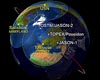
This artist's rendering shows a "family portrait" of Jason-1, Topex/Poseidon, and OSTM/Jason-2, all NASA satellites that collect data about sea surface heights around the world. Sea surface heights are one component helpful to hurricane forecasters, as higher seas indicate warmer waters (that power storms) while lower seas indicate cooler waters (such as those in La Nina events in the eastern Pacific). |
|
| The content herein, unless otherwise known to be public domain, are Copyright Space.TV Corporation. AFP and UPI Wire Stories are copyright Agence France-Presse and United Press International. ESA Portal Reports are copyright European Space Agency. All NASA sourced material is public domain. Additional copyrights may apply in whole or part to other bona fide parties. Advertising does not imply endorsement, agreement or approval of any opinions, statements or information provided by Space.TV Corp on any Web page published or hosted by Space.TV Corp. Privacy Statement |

