|
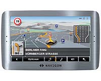
Chicago IL (SPX) Mar 25, 2008 NAVIGON has climbed into the number four position in the personal navigation category just six months after the company's maiden launch of personal navigation devices (PNDs) by earning a market share of 11.5 percent (unit volume shares) in February, according to The NPD Group's Retail Tracking Service. NPD also reported NAVIGON's feature-packed NAVIGON 2100 grabbed the number two slot as the best-selling portable GPS device among all units sold in February. Two months after its debut, the NAVIGON 2100 broke into the ranks of the top ten best selling systems in December 2007, before climbing to the number two spot in February 2008. NAVIGON credits the NAVIGON 2100's momentum to the unit's compelling high-end features such as Reality View(TM) and text-to-speech, as well as its wallet-friendly MSRP of $249. NAVIGON is weeks away from launching a follow-up to the NAVIGON 2100, the NAVIGON 2100 max, which features a wider, 4.3 inch screen, spoken driving directions via text-to-speech, DirectHelp(TM) to alert roadside assistance providers and NAVIGON's exclusive 3D Reality View to navigate complex interchanges. The NAVIGON 2100 max will sell for an MSRP of $299 and can be purchased with FreshMaps, a service accessory that provides up to 12 map updates in three years and is compatible across the company's product portfolio. "NAVIGON provides more features that matter and we're finding this is really resonating with consumers," said Andreas Hecht, NAVIGON's president for the Americas. "Our portfolio exemplifies that we put the customer first and that we invest a great deal of thought and energy into making them happy they purchased a NAVIGON." Related Links NAVIGON GPS Applications, Technology and Suppliers
 Englewood CO (SPX) Mar 25, 2008
Jeppesen was recently granted FAA approval for its Airport Moving Map application for Class 2 EFB devices, and is the first and only company to have received approval. Jeppesen Airport Moving Map uses a detailed database to dynamically render maps of the airport surface, and through the use of GPS technology, show pilots their position ("own-ship") on the airport surface. |
|
| The content herein, unless otherwise known to be public domain, are Copyright Space.TV Corporation. AFP and UPI Wire Stories are copyright Agence France-Presse and United Press International. ESA Portal Reports are copyright European Space Agency. All NASA sourced material is public domain. Additional copyrights may apply in whole or part to other bona fide parties. Advertising does not imply endorsement, agreement or approval of any opinions, statements or information provided by Space.TV Corp on any Web page published or hosted by Space.TV Corp. Privacy Statement |