 |
Washington (AFP) May 17, 2011 The US space agency said Tuesday it is preparing to launch a satellite to observe levels of salt on the surface of the world's oceans and how changes in salinity may be linked to future climate. The June 9 launch of Aquarius/SAC-D comes three months after NASA lost Glory, a 424-million-dollar Earth-observing satellite that failed to separate properly from its rocket launcher and plunged into the ocean. The orbiting science instrument will aim to map the entire open ocean every seven days from its position 408 miles (657 kilometers) above Earth, producing monthly estimates that show how salt levels change over time and location. "There are vast tracts of the ocean where salinity has never been collected, ever," said Eric Lindstrom, Aquarius program scientist at NASA, describing the high level of precision expected from the mission. "We are going to be sampling the whole planet in one week," he told reporters. While a European satellite was launched in 2009 to measure soil moisture and ocean salinity, the Aquarius/SAC-D is a global collaboration -- with partner Argentina as well as France, Brazil, Canada and Italy -- that will add to scientists' knowledge of the oceans in novel ways. "Aquarius will map global variations in salinity in unprecedented detail, leading to new discoveries that will improve our ability to predict future climate," said principal investigator Gary Lagerloef of the Earth & Space Research in Seattle, Washington. Scientists from the European Space Agency who launched the Soil Moisture and Ocean Salinity (SMOS) mission have been working in parallel and sometimes in partnership with NASA and Argentina's space agency, Comision Nacional de Actividades Espaciales (CONAE) as the two separate missions took shape, he said. SMOS is a dual-purpose mission whose main focus is soil moisture, while Aquarius is aimed primarily at measuring ocean salinity, which plays a key role in exchanges of water and heat in the atmosphere. "It has been a strong cooperative effort," said Lagerloef. "Once we have both of these missions in orbit, we will compare results, we will intercalibrate them," he told reporters. "We will do a lot of things cooperatively to provide the best information about ocean surface salinity to the scientific community that we possibly can." The satellite observatory is also to carry seven additional instruments to "collect environmental data for a wide range of applications, including studies of natural hazards, air quality, land processes and epidemiology," NASA said.
Share This Article With Planet Earth
Related Links Earth Observation News - Suppiliers, Technology and Application
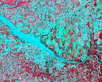 Tornado Challenges Satellite Damage Track Detection Techniques
Huntsville AL (SPX) May 17, 2011 The Short-term Prediction Research and Transition, or SPoRT, team has used satellite data from the North Alabama region to identify tornado damage from the April 27th super storm outbreak. NASA's Terra satellite, part of the Earth Observing System of satellites, captured images of the damage path. An instrument aboard Terra called the Advanced Spaceborne Thermal Emission and Reflection Rad ... read more |
|
| The content herein, unless otherwise known to be public domain, are Copyright 1995-2010 - SpaceDaily. AFP and UPI Wire Stories are copyright Agence France-Presse and United Press International. ESA Portal Reports are copyright European Space Agency. All NASA sourced material is public domain. Additional copyrights may apply in whole or part to other bona fide parties. Advertising does not imply endorsement,agreement or approval of any opinions, statements or information provided by SpaceDaily on any Web page published or hosted by SpaceDaily. Privacy Statement |


 del.icio.us
 Digg
Digg Reddit
 YahooMyWeb
 Google