|
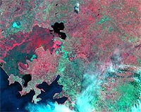
Greenbelt MD (SPX) Nov 24, 2008 NASA, the US Agency for International Development (USAID) and their partners are in Nairobi, Kenya, to launch SERVIR-Africa, a program that helps scientists, government leaders and local communities address concerns related to natural disasters, disease outbreaks, biodiversity and climate change. SERVIR, Spanish for "to serve," integrates satellite resources of the U.S. and other countries into a Web-based Earth information system, putting previously inaccessible information into action locally. SERVIR has been operational in Central America, the Caribbean and southern Mexico since 2005. Now, through the support of multiple government agencies, non-government organizations, and research institutes, USAID and NASA are expanding the system to Africa in partnership with the Regional Center for Mapping of Resources for Development (RCMRD) in Nairobi. The program is led by NASA's Marshall Space Flight Center, with contributions from the Goddard Space Flight Center. One of the first applications of SERVIR-Africa, provided by GSFC, will use NASA earth science data from TRMM, EO-1, and MODIS to better predict areas at risk for severe flooding. One such location (pictured) is the Lake Victoria Basin in Kenya, Uganda and Tanzania, where nearly 30 million people live. The Nzoia River basin lies entirely within the Lake Victoria basin in Kenya. The SERVIR-Africa team captured multispectral imagery of the Nzoia River basin from the NASA's EO-1 satellite on August 23, 2008, to provide baseline imagery of this frequently flooded area for future analysis. The NASA's Earth Observing One (EO-1) satellite celebrates its 8th birthday today. The satellite launched on November 21, 2000, with an initial design and mission life of one year, but has continued successful operations for more than 7 years past the initial mission. EO-1 has performed over 76,000 images to date. Related Links NASA Goddard Space Flight Center Earth Observation News - Suppiliers, Technology and Application
 El Segundo CA (SPX) Nov 21, 2008
Raytheon has completed integration, baseline performance characterization, and vibration testing of a space-based sensor intended to help NASA scientists better understand the effect of aerosols on global warming and climate change. |
|
| The content herein, unless otherwise known to be public domain, are Copyright Space.TV Corporation. AFP and UPI Wire Stories are copyright Agence France-Presse and United Press International. ESA Portal Reports are copyright European Space Agency. All NASA sourced material is public domain. Additional copyrights may apply in whole or part to other bona fide parties. Advertising does not imply endorsement, agreement or approval of any opinions, statements or information provided by Space.TV Corp on any Web page published or hosted by Space.TV Corp. Privacy Statement |