 |
Pasadena CA (JPL) Mar 17, 2011 A new before-and-after image pair from the Advanced Spaceborne Thermal Emission and Reflection Radiometer (ASTER) instrument on NASA's Terra spacecraft shows a region of Japan's northeastern coast, northeast of the city of Sendai, which was affected by the March 11, 2011 tsunami. The images show the coastal cities of Ofunato and Kesennuma, located about 90 kilometers (55 miles) northeast of Sendai. Ofunato has a population of about 42,000, while the population of Kesennuma is about 73,000. Areas covered by vegetation are shown in red, while cities and unvegetated areas are shown in shades of blue-gray. The image on the left was acquired on March 14, 2011; the image on the right was acquired in August 2008. When compared closely, vegetation is no longer visible in many coastal areas in the new image, particularly around Kesennuma. Scientists believe this is most likely due to the effects of the tsunami. The images show an area located at 39.4 degrees north latitude, 141.9 degrees east longitude, and cover an area of 28 by 46 kilometers (17 by 27 miles).
Share This Article With Planet Earth
Related Links Advanced Spaceborne Thermal Emission and Reflection Radiometer (ASTER) Earth Observation News - Suppiliers, Technology and Application
 National Flooding Exercise Hones Use Of Satellites To Improve Disaster Mitigation
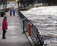
London, UK (SPX) Mar 17, 2011 Last week a team of space experts led by British company DMCii participated in a national flooding exercise, "Exercise Watermark", to determine how satellite imagery, satellite communications and satellite navigation could be used to improve UK emergency response. The team represented an ongoing project funded via the UK's Technology Strategy Board (TSB) as part of its contribution to the Europe ... read more |
|
| The content herein, unless otherwise known to be public domain, are Copyright 1995-2010 - SpaceDaily. AFP and UPI Wire Stories are copyright Agence France-Presse and United Press International. ESA Portal Reports are copyright European Space Agency. All NASA sourced material is public domain. Additional copyrights may apply in whole or part to other bona fide parties. Advertising does not imply endorsement,agreement or approval of any opinions, statements or information provided by SpaceDaily on any Web page published or hosted by SpaceDaily. Privacy Statement |


 del.icio.us
 Digg
Digg Reddit
 YahooMyWeb
 Google