|
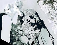
Greenbelt MD (SPX) Mar 08, 2007 Researchers from NASA and the U.S. Geological Survey (USGS), Golden, Colo., have woven together more than a thousand images from the Landsat 7 satellite to create the most detailed, high-resolution map ever produced of Antarctica. The Landsat Image Mosaic of Antarctica (LIMA) offers views of the coldest continent on Earth in 10 times greater detail than previously possible. "These images give us incredibly detailed views of the Antarctic ice sheet surface and serve as maps for many locations that have never been mapped before," said Robert Bindschadler, chief scientist of the Laboratory for Hydrospheric and Biospheric Sciences at NASA's Goddard Space Flight Center, Greenbelt, Md. Bindschadler oversaw the selection of the scenes used to create the mosaic. Researchers at NASA, the U.S. Geological Survey, and the British Antarctic Survey in Cambridge, England, have launched a Web site with support from the National Science Foundation to offer public access to the image mosaic. This site contains original images and close-ups of various areas of Antarctica, all available for download. The research group will continue to release images through this summer. "The resolution sensitivity of the Landsat sensor is well beyond that of even the most state-of-the-art digital camera," Bindschadler said. "It's able to record subtle variations in the ice sheet's surface that tell us more about ice sheet features, the flow of the ice sheet and changes in the ice sheet's surface." According to Bindschadler, researchers will have special interest in the new ability to zoom in on areas like Antarctica's dry valleys that lie between the ice sheets. To date, only aerial images of these locations were possible. The carefully collaged images that compose LIMA now provide clear, high-resolution images. Through special processing of images captured by Landsat 7's Enhanced Thematic Mapper Plus sensor, scientists were able to produce a true color, nearly cloud-free view of Antarctica. For the process, researchers use specialized software to stack several images of various Antarctic locations to create one larger image. The researchers also arranged the images on top of one another in a sequence that allows clear views to the surface, removing the effects of clouds contained in some images. "Having this capability is quite exciting. Using the Web portal, scientists as well as students, teachers and others will be able to zoom in to a specific Antarctic region and adjust for various levels of detail," said Bindschadler. "This will be like having a room with a tremendous view, a detailed view from space aboard Landsat to peer down as if you were just above the ice sheet's surface." LIMA is one of more than 228 projects funded in conjunction with the International Polar Year, an initiative 63 cooperating countries launched in March to improve scientific understanding of Earth's polar regions. The U.S. Geological Survey manages the NASA-designed Earth-observing satellites of the Landsat Program, first launched in 1972. During the past three decades, Landsat sensors have captured two million high-resolution digital photographs of Earth's continents and surrounding coastal regions, enabling scientists to study various aspects of the planet. Related Links LIMA images on the Antarctic Portal Landsat Beyond the Ice Age Beyond the Ice Age
 New York NY (SPX) Mar 07, 2007
Just as explorers once searched the vast reaches of Africa's Nile River for clues to its behavior and ultimate source, modern-day scientists are searching Antarctica for its hidden lakes and waterways that can barely be detected at the surface of the ice sheet. In a new study, researchers have unearthed how water from this vast subglacial system contributes to the formation of ice streams, and how it plays a crucial role in transporting ice from the remote interior of Antarctica toward the surrounding ocean. |
|
| The content herein, unless otherwise known to be public domain, are Copyright Space.TV Corporation. AFP and UPI Wire Stories are copyright Agence France-Presse and United Press International. ESA Portal Reports are copyright European Space Agency. All NASA sourced material is public domain. Additional copyrights may apply in whole or part to other bona fide parties. Advertising does not imply endorsement, agreement or approval of any opinions, statements or information provided by Space.TV Corp on any Web page published or hosted by Space.TV Corp. Privacy Statement |