|
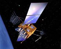
Denver CO (SPX) Jan 24, 2008 The Global Positioning System (GPS) Block IIR and IIR-M satellite constellation, designed and built by Lockheed Martin to provide significantly improved navigation capabilities for military and civilian users worldwide, has accumulated over 75 years of successful on-orbit operations. GPS provides essential services including situational awareness and precision weapon guidance for the military. It is also an information resource supporting a wide range of civil, scientific and commercial functions -- from air traffic control to the Internet -- with precision location and timing information. Lockheed Martin Space Systems, Valley Forge, Pa., is the prime contractor for the GPS IIR program. The company designed and built 21 IIR spacecraft for the Global Positioning Systems Wing, Space and Missile Systems Center, Los Angeles Air Force Base, Calif. The final eight spacecraft, designated Block IIR-M, were modernized to enhance operations and navigation signal performance for military and civilian GPS users around the globe. ITT, Clifton, N.J. supplied all 21 navigation payloads for both the IIR and IIR-M spacecraft. GPS IIR satellites have been delivering improved navigation capabilities to the U.S. military and civil users since the first successful launch of a IIR satellite on July 23, 1997. There are currently 12 operational Block IIR and five IIR-M satellites within the overall 30-spacecraft constellation. The team is now gearing up for the launch of the sixth IIR-M satellite scheduled for liftoff in March from Cape Canaveral. "We are proud of this milestone and our partnership with the Air Force in providing reliable, high-performance GPS spacecraft that not only help our warfighters achieve their missions with greater speed and effectiveness, but also serve millions of civil users around the globe," said Don DeGryse, Lockheed Martin's Vice President of Navigation Systems. "We look forward to achieving mission success and delivering even greater navigation capabilities as we prepare to launch the next modernized satellite." Based on the navigation user range error, which measures GPS accuracy, the Block IIR and IIR-M satellites enable properly equipped users to determine precise time and velocity, and worldwide latitude, longitude and altitude to within one meter. Air Force Space Command's 2nd Space Operations Squadron (2 SOPS) at Schriever Air Force Base, Colo., manages and operates the GPS constellation for both civil and military users. Lockheed Martin is also leading a team which includes ITT and General Dynamics in the competition to build the U.S. Air Force's next-generation Global Positioning System, GPS Block III. The next-generation program will improve position, navigation, and timing services for the warfighter and civil users worldwide and provide advanced anti-jam capabilities yielding improved system security, accuracy and reliability. A multi-billion dollar development contract is scheduled to be awarded by the Global Positioning Systems Wing, Space and Missile Systems Center, Los Angeles Air Force Base, Calif. in early 2008. Related Links GPS Applications, Technology and Suppliers
 Moscow (RIA Novosti) Jan 24, 2008
Russian space agency Roscosmos must take responsibility for the operational shortcomings of the Glonass satellite navigation system, a first deputy prime minister said on Wednesday. Glonass (Global Navigation Satellite System), Russia's equivalent of the U.S. Global Positioning System (GPS), is designed for both military and civilian use and allows users to identify their positions in real time. |
|
| The content herein, unless otherwise known to be public domain, are Copyright Space.TV Corporation. AFP and UPI Wire Stories are copyright Agence France-Presse and United Press International. ESA Portal Reports are copyright European Space Agency. All NASA sourced material is public domain. Additional copyrights may apply in whole or part to other bona fide parties. Advertising does not imply endorsement, agreement or approval of any opinions, statements or information provided by Space.TV Corp on any Web page published or hosted by Space.TV Corp. Privacy Statement |