|
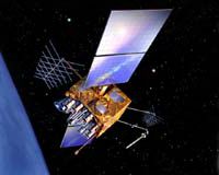
Cape Canaveral FL (SPX) Dec 18, 2007 The fifth in a series of eight modernized Global Positioning System Block IIR (GPS IIR-M) satellites built by Lockheed Martin for the U.S. Air Force is ready for launch aboard a Delta II rocket on Dec. 20, from Cape Canaveral Air Force Station, Fla. The spacecraft, designated GPS IIR-18M, is a modernized version of the Block IIR series designed to enhance the GPS constellation for military and civilian GPS users around the globe. The modernized series delivers increased signal power to receivers on the ground, two new military signals for improved accuracy, enhanced encryption and anti-jamming capabilities for the military, and a second civil signal to provide users with an open access signal on a different frequency. The GPS constellation provides critical situational awareness and precision weapon guidance for the military and supports a wide range of civil, scientific and commercial functions - from air traffic control to the Internet - with precision location and timing information. "Built by a dedicated, experienced team, this advanced satellite will provide another step forward in our customer's goal to modernize the GPS constellation," said Don DeGryse, Lockheed Martin's vice president of Navigation Systems. "We are extremely proud of our partnership with the Air Force to maintain and enhance the vitally important GPS mission and we look forward to achieving mission success for our customer." Lockheed Martin Navigation Systems, Valley Forge, Pa. prime contractor for the GPS IIR program and navigation payload provider ITT of Clifton, N.J. designed and built 21 IIR spacecraft and subsequently modernized eight of those spacecraft, designated Block IIR-M, for the Global Positioning Systems Wing, Space and Missile Systems Center, Los Angeles Air Force Base, Calif. The Global Positioning System enables properly equipped users to determine precise time and velocity and worldwide latitude, longitude and altitude to within a few meters. Air Force Space Command's 2nd Space Operations Squadron (2SOPS), based at Schriever Air Force Base, Colo., manages and operates the GPS constellation for both civil and military users. Related Links GPS Applications, Technology and Suppliers
 Chicago IL (SPX) Dec 17, 2007
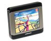
NAVTEQ reports that Lowrance has selected NAVTEQ as the map provider for its new mobile navigation device. The XOG Crossover Navigation GPS will utilize comprehensive NAVTEQ maps for the United States and Canada. |
|
| The content herein, unless otherwise known to be public domain, are Copyright Space.TV Corporation. AFP and UPI Wire Stories are copyright Agence France-Presse and United Press International. ESA Portal Reports are copyright European Space Agency. All NASA sourced material is public domain. Additional copyrights may apply in whole or part to other bona fide parties. Advertising does not imply endorsement, agreement or approval of any opinions, statements or information provided by Space.TV Corp on any Web page published or hosted by Space.TV Corp. Privacy Statement |