|
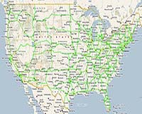
Kirkland WA (SPX) Apr 11, 2008 INRIX has introduced Nationwide Traffic Alerts on more than 100,000 miles of major arterials, freeways and highways, including the entire U.S. Interstate Highway System, with never-before availability of real-time traffic alerts highlighting abnormal traffic congestion across the nation. MapQuest and other INRIX customers intend to deliver INRIX Nationwide Traffic Alerts for major urban, interurban and rural roadways, highlighting unusual congestion wherever it may occur across the country from a myriad of sources. INRIX uniquely can provide this traffic information, based upon its sophisticated data fusion of real-time speed data from its exclusive Smart Dust Network of over 800,000 GPS-enabled vehicles, data collected anonymously from mobile phone devices, and traditional road sensors covering more than 9,000 miles of road. INRIX's technology platform processes billions of data points per month and uses intelligent analytics to identify patterns of movement that help detect traffic abnormalities on roads where coverage was either limited or simply didn't exist before. Unlike areas with fairly comprehensive road-sensor networks such as the I-10 freeway in Los Angeles or the I-5 corridor in Seattle where traffic information is readily available, INRIX Nationwide Traffic Alerts allows the long-haul truck driver traveling on I-26 in South Carolina to receive alerts of traffic delays caused by extreme weather at the I-95 junction and choose an alternate route to avoid the congestion, greatly improving the chances of making his delivery to Columbia on time. Similarly, the leisure traveler heading to Lake Tahoe from San Francisco for Spring break can now be alerted ahead of time when a jack-knifed 18-wheeler brings traffic to a 3-hour standstill along Highway 50. INRIX Nationwide Traffic Alerts represents a radical improvement in traffic information available to the two hundred million drivers in the U.S. Websites, government agencies, automobile manufacturers, fleet management service providers, and portable navigation device makers are among the many who can benefit from INRIX's powerful new tool. "More and more MapQuest users are planning trips online and Nationwide Traffic Alerts will make destination planning even more convenient. MapQuest users will be able to get information about unusual traffic congestion as it happens, as well as highway construction and planned traffic impeding events while online or have alerts sent directly to their mobile devices," said Christian Dwyer, Senior Vice President and General Manager of MapQuest. "INRIX continues to innovate and is committed to providing the most comprehensive set of traffic data in the U.S." INRIX's Nationwide Traffic Alerts is different than anything else on the market today. Traffic data is generated by INRIX's award-winning Smart Dust Network, which fuses together the most comprehensive amount of traffic information available anywhere -- collecting data anonymously every minute or two from vehicles across the country which automatically send their position and speed back to the INRIX Operations Center. The INRIX Fusion Engine then blends this information together with real-time data from dozens of other sources such as real-time incident data, construction data and events and then delivers real-time information regarding current road speeds to INRIX customers. That way, INRIX customers always have the best, most up-to-date traffic available. The result is real-time traffic speed and flow information on more than 55,000 miles in 106 metropolitan areas today, plus more than 2500 alerts per day on the additional 45,000 roadway miles in urban and interurban areas which have limited or non-existent traditional road sensors. Alerts are automatically created as individual incident messages alerting drivers to roads that are experiencing abnormal traffic congestion at that time of day. "The majority of traffic information available today is only for a limited set of roads in major urban areas," said Bryan Mistele, president and CEO of INRIX. "This is the first time that consumers and businesses have access to traffic congestion data across our country's interstates. INRIX uniquely is able to deliver this solution by leveraging our exclusive strategic relationships with national and regional fleets, relationships that provide us mobile-phone based data, and smartly applying our technology to solve complex problems." Related Links INRIX GPS Applications, Technology and Suppliers
 New York NY (SPX) Apr 11, 2008
Tracking of cargo containers and their contents from departure to delivery has clear benefits for the industrial and transportation sectors: increased visibility and security of goods in transit. A further potential benefit - greater public safety and security - is a subject of debate. But it is frequently true that combinations of the three available tracking technologies, rather than any one in isolation, promise the maximum value for investment. |
|
| The content herein, unless otherwise known to be public domain, are Copyright Space.TV Corporation. AFP and UPI Wire Stories are copyright Agence France-Presse and United Press International. ESA Portal Reports are copyright European Space Agency. All NASA sourced material is public domain. Additional copyrights may apply in whole or part to other bona fide parties. Advertising does not imply endorsement, agreement or approval of any opinions, statements or information provided by Space.TV Corp on any Web page published or hosted by Space.TV Corp. Privacy Statement |