 |
Fairfield CA (SPX) Aug 17, 2010 After thousands of years of improving man's first survival skill, a new method to improve the hunt has hit the market. Hunters are going high-tech with a new program designed to improve their hunting skills by gathering, detailing, and retaining performance information about bagged game over entire seasons or years. An interesting new application tracks the information related to the hunt and bagged game, (example: elk, deer, waterfowl, etc), and includes an extensive wildlife database, GPS location data, weather, moon phases, and hunt photos that get logged on the iPhone. The app can then share data through email or Facebook if the hunter chooses. The application, called the Hunter's iJournal, is available for Apple's iPhone, iPad and iPod Touch portable devices through the app store. The program doesn't stop there. "Our unique program allows the hunter to track data that can be used to improve their skill and knowledge over time, giving the hunter information to make adjustments based on factual data, and not just relying on their memories," says inventor and owner/partner, David Borges. "The system allows you to graph hunt results and is an advance in studying how, when, and where you perform your best." "Information related to the hunting experience are what hunters enjoy recalling well after the hunt, even years later. Now, hunters can keep accurate records from the field by using their mobile devices. They can even record data for their kids since the system allows for multiple profiles," says Borges.
Share This Article With Planet Earth
Related Links Hunter's iJournal GPS Applications, Technology and Suppliers
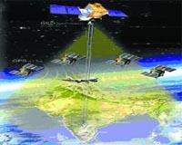 India Launches Satellite-Based Navigation System
New Delhi, India (PTI) Aug 13, 2010 India Tuesday launched a satellite-based navigation system to aid air traffic in the region and joined a select club of nations which have similar capabilities. Civil Aviation Minister Praful Patel launched the Global Position System Aided Geo Augmented Navigation (gagan) based on a constellation of 24 satellites positioned in six earth-centred orbital planes. gagan will provide seam ... read more |
|
| The content herein, unless otherwise known to be public domain, are Copyright 1995-2010 - SpaceDaily. AFP and UPI Wire Stories are copyright Agence France-Presse and United Press International. ESA Portal Reports are copyright European Space Agency. All NASA sourced material is public domain. Additional copyrights may apply in whole or part to other bona fide parties. Advertising does not imply endorsement,agreement or approval of any opinions, statements or information provided by SpaceDaily on any Web page published or hosted by SpaceDaily. Privacy Statement |


 del.icio.us
 Digg
Digg Reddit
 YahooMyWeb
 Google