illustration only
illustration only |
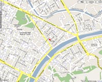
Cellular transmission services are provided by the company's wireless carrier partner, AT and T, to deliver real-time geographic coordinates, rendered on Google Maps, to subscribers via secure internet connections.
Unlike other element topology-management functions, which rely on static maps or geographic information systems (GIS), Google Maps API Premier provides a rich, interactive interface that includes panning, zooming, satellite images and street-level views (in certain locations).
Patrick Bertagna, GTX Corp CEO and President noted, "Choosing Google Maps API Premier as our primary mapping interface further illustrates our commitment to establishing relationships with best-in-class providers to enhance our users' experience. In this case, we're giving our customers the most advanced mapping tool available, allowing them to offer a viewing perspective second to none."
"Google is excited to have GTX Corp integrate our Google Maps API Premier into its products," said Dan Israel, Product Marketing Manager, Google Enterprise. "GTX Corp's use of Google Maps will help bring its personal location services to a broader audience."
Intuitive, interactive maps and satellite images become especially important as users begin to integrate real time tracking capabilities for the purpose of seeing the whereabouts of loved ones and valuable personal assets into their daily life activities.
With Google Maps API Premier, viewers can easily track street addresses and specific locations. This capability also allows for the historical travel data (bread crumb trails) to be mapped and preserved for future analysis.
Related Links
 Paris, France (SPX) Jun 18, 2008
| The content herein, unless otherwise known to be public domain, are Copyright Space.TV Corporation. AFP and UPI Wire Stories are copyright Agence France-Presse and United Press International. ESA Portal Reports are copyright European Space Agency. All NASA sourced material is public domain. Additional copyrights may apply in whole or part to other bona fide parties. Advertising does not imply endorsement, agreement or approval of any opinions, statements or information provided by Space.TV Corp on any Web page published or hosted by Space.TV Corp. Privacy Statement |