|
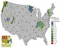
Woods Hole MA (SPX) Feb 15, 2008 Scientists at the Woods Hole Research Center working to produce the "National Biomass and Carbon Dataset" for the year 2000 (NBCD2000) are releasing data from nine project mapping zones. All NBCD2000 data products are being made available for download on a zone-by-zone basis and free of charge from the NBCD2000 project website. Through a combination of NASA satellite datasets, topographic survey data, land use/land cover information, and extensive forest inventory data collected by the USDA Forest Service - Forest Inventory and Analysis Program (FIA), NBCD2000 will provide an invaluable baseline for quantifying the carbon stock in U.S. forests and will improve current methods of assessing the carbon flux between forests and the atmosphere. According to Dr. Josef Kellndorfer, an associate scientist at the Center and project leader, "The availability of a high resolution dataset containing estimates of forest biomass and associated carbon stock is an important step forward in enabling researchers to better understand the North American carbon balance." As part of the NBCD2000 initiative, begun in 2005 and funded by NASA's Earth Science Program with additional support from the USGS/LANDFIRE, mapping is being conducted within 67 ecologically diverse regions, termed "mapping zones", which span the conterminous United States. Of the nine completed zones, 5 were finished during a 2-year pilot phase. Work on the remaining zones will be completed at a rate of roughly one zone every seven days. The project is scheduled for completion in early 2009. Wayne Walker, a research associate at the Center who is also working on the project adds, "The data sets that are now available should be of interest to natural resource managers across the U.S. For the first time, high resolution estimates of vegetation canopy height and biomass are being produced consistently for the entire conterminous U.S." Within each mapping zone data from the 2000 Shuttle Radar Topography Mission are combined with topographic survey data from the National Elevation Dataset (NED) to produce a radar-based map of vegetation canopy height. Subsequently, the map is used to generate estimates of actual vegetation height, biomass, and carbon stock using survey data from the U.S. Forest Service - FIA program and ancillary data sets from the National Land Cover Database 2001 (NLCD2001) project. The NLCD2001 data layers are crucial inputs to the NBCD2000 project as they provide land cover and canopy density information used in the stratification/calibration process. Diane Wickland, the program manager for NASA's Terrestrial Ecology Program, comments, "Because this is the first systematic, regional-scale study that uses radar data to quantify carbon storage in vegetation, the end result will not only provide valuable information on how well we can do with existing data, but will allow us to see how we might improve and refine requirements for future, more capable missions like DESDynI, which has been recommended by the National Research Council Decadal Survey on Earth Observation." Related Links NBCD2000 project website Forestry News - Global and Local News, Science and Application
 Ann Arbor, Mich. (UPI) Feb 13, 2008
 U.S. scientists have determined deforestation and social marginalization increase the risk of acquiring an infectious, tropical skin disease. |
|
| The content herein, unless otherwise known to be public domain, are Copyright Space.TV Corporation. AFP and UPI Wire Stories are copyright Agence France-Presse and United Press International. ESA Portal Reports are copyright European Space Agency. All NASA sourced material is public domain. Additional copyrights may apply in whole or part to other bona fide parties. Advertising does not imply endorsement, agreement or approval of any opinions, statements or information provided by Space.TV Corp on any Web page published or hosted by Space.TV Corp. Privacy Statement |