|
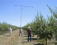
Fresno CA (SPX) Jul 21, 2008 Horticultural crops account for almost 50% of crop sales in the United States, and these crops are carefully managed to ensure good quality. But more information is needed about the crops' growth and response to seasonal and climatic changes so that management practices such as irrigation can be precisely scheduled. Existing research can be difficult to generalize because of variations in crops, planting densities, and cultural practices. Determining growth stage, size, and water needs are especially important for horticultural crops because most crops are grown in limited water environments and require irrigation. The measurement of "canopy light interception" is a primary means of determining water and irrigation needs. Fractional canopy cover (CC) is a relatively easily measured property that is a good indicator of light interception. Canopy cover, the percent of the soil surface covered by plant foliage, is an important indicator of stage of growth and crop water use in horticultural crops. Methods of using remote sensors to determine canopy cover in major crops have been studied for years, but the studies have not included most horticultural crops. Thomas J. Trout, Research Leader at the U.S. Department of Agriculture's Agricultural Research Service, along with colleagues from the NASA Earth Science Division, recently published a study that addresses the relationship of remotely sensed normalized difference vegetation index (NDVI) relative to canopy cover of several major horticultural crops in commercial fields. The research team measured canopy cover of 11 different annual and perennial horticultural crops in various growth stages on 30 fields in California's San Joaquin Valley with a handheld multispectral digital camera. Canopy cover was compared with NDVI values calculated from Landsat 5 satellite imagery. According to Trout, "The NDVI was highly correlated and linearly related with measured CC across the wide range of crops, canopy structures, and growth stages, and predicted CC with mean absolute error of 0.047 up to effective full cover. These results indicate that remotely sensed NDVI may be an efficient way to monitor growth stage, and potentially irrigation water demand, of horticultural crops." The research indicates that NDVI can potentially provide field-specific and regional estimates of CC for horticultural crops with minimal requirement for supporting information. This new information may also be useful to improve estimates of crop growth stage and water use. Related Links American Society for Horticultural Science Farming Today - Suppliers and Technology
 United Nations (AFP) July 18, 2008
UN chief Ban Ki-moon on Friday called for a sharp hike in world farm output, warning that high food and fuel prices threatened much of the progress made in reaching global poverty-reduction targets. |
|
| The content herein, unless otherwise known to be public domain, are Copyright Space.TV Corporation. AFP and UPI Wire Stories are copyright Agence France-Presse and United Press International. ESA Portal Reports are copyright European Space Agency. All NASA sourced material is public domain. Additional copyrights may apply in whole or part to other bona fide parties. Advertising does not imply endorsement, agreement or approval of any opinions, statements or information provided by Space.TV Corp on any Web page published or hosted by Space.TV Corp. Privacy Statement |