|
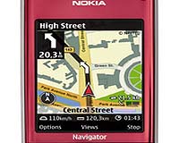
Barcelona, Spain (SPX) Feb 12, 2008 Nokia has announced that the Beta version of Nokia Maps 2.0 is ready for you to take out for a spin. Nokia Maps is taking its mapping and navigation experiences to the next level by enhancing its pedestrian navigation, adding multimedia city guides, offering satellite images, and sporting a redesigned user interface. Nokia Maps 2.0 adds Walk, a pedestrian focused navigation component to the application, while still offering Drive, a world class car navigation system. The pedestrian navigation efficiently walks you from A to B with visual turn-by-turn guidance. It helps you to locate yourself by giving information about the surrounding buildings, streets and parks (including pathways through the park) and in newer handsets, like the Nokia 6210 Navigator, points the direction in which you are walking; using the handset's built in compass for orientation. The new Nokia Maps 2.0 update also adds the option to purchase first-class multimedia guides that feature photos, videos and audio streams to enlighten your journey even more. As with the previous version of Nokia Maps, map users will receive a free 3-day Navigation trial, for Walk and Drive, plus an additional free 10 minute City Guide trial. "By taking navigation services out of the car and onto the sidewalk, Nokia is enabling people to explore and discover what's around them with the confidence of a local," said Michael Halbherr, vice president, Nokia location based services. "By combining the integrated compass of the Nokia 6210 Navigator, with the speed and accuracy of assisted GPS, Nokia Maps 2.0 provides a unique experience with which other less accurate mobile navigation applications can't compete." Upgrading to the GPS navigation option enables your mobile to become a powerful connected personal navigation device, that provides clear, turn-by-turn visual and voice guidance. If your Nokia device doesn't have built-in GPS, you can also use an external GPS module with a compatible device. Nokia Maps 2.0 will also have, for an optional fee, real-time traffic feeds with dynamic re-routing in 18 European countries. With vector maps provided by TeleAtlas and Navteq, Nokia Maps now has maps covering over 200 countries, with over 70 of them navigable. Nokia Maps 2.0 can also lead you to the nearest transit station using localized icons in 17 cities so you can hop on the Metro to get across town. While you are on riding on the Metro you can discover and explore new places using the hybrid satellite views or by purchasing one of the new multimedia city guides from companies like Berlitz. The expert advice on where to go and what to do, combined with the integrated Nokia mobile search, helps Nokia fulfill its goal of bringing people context aware Internet services forward. Nokia also announced that they are planning on bringing Nokia Maps to the mass market with a Series 40 version of Nokia Maps, which will be ready during the 1st half of 2008. Devices based on the Series 40 platform accounted for a large portion of the more than 437-million devices Nokia estimates it had cumulatively shipped by the end of 2007. The new version of Nokia Maps 2.0 for selected devices is available on the Nokia Beta Labs website. Beta Labs shares some of the exciting new ideas that Nokia is working on and let users help shape their future development. A strong online community has developed around Beta Labs, attracting especially technology savvy, early adopter mobile enthusiasts. The current version of Nokia Maps and the Nokia Map Loader are freely available for download for selected devices. Related Links Nokia Maps GPS Applications, Technology and Suppliers
 Palo Alto CA (SPX) Feb 12, 2008
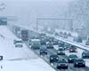
Nokia and UC Berkeley researchers have tested technology that could soon transform the way drivers navigate through congested highways and obtain information about road conditions. One hundred cars equipped with the GPS-enabled Nokia N95, and driven by students from the University of California, traveled a 10-mile stretch of highway near San Francisco to show how real-time traffic information can be collected from the GPS feed, while preserving the privacy of the devices' owners. |
|
| The content herein, unless otherwise known to be public domain, are Copyright Space.TV Corporation. AFP and UPI Wire Stories are copyright Agence France-Presse and United Press International. ESA Portal Reports are copyright European Space Agency. All NASA sourced material is public domain. Additional copyrights may apply in whole or part to other bona fide parties. Advertising does not imply endorsement, agreement or approval of any opinions, statements or information provided by Space.TV Corp on any Web page published or hosted by Space.TV Corp. Privacy Statement |