|
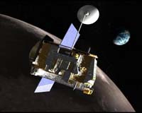
Greenbelt MD (SPX) Apr 20, 2007 Of the two luminaries that dominate our sky, it is the moon that is of particular interest to the Lunar Reconnaissance Orbiter (LRO) project. The LRO will travel to the moon in late fall 2008, mapping the surface to help pave the way for humans to return. It will help prepare us for extended surface exploration on the moon and for subsequent missions to Mars and other distant destinations. Lunar surface exploration will help us to practice living, working, and gathering science data before we venture into riskier territory. The Lunar Reconnaissance Orbiter will take the first strides in researching a complex habitat -- a hostile environment without atmosphere or clouds, with daytime temperatures reaching as high as 250 degrees Fahrenheit (123 degrees Celsius) and as low as minus 450 degrees Fahrenheit (233 degrees Celsius), and sunlight lasting two weeks. The spacecraft will identify the volatile terrain so we can land safely. It should also be able to identify water on the surface, if it sees it. The spacecraft being built at NASA's Goddard Space Flight Center in Greenbelt, Md., will include six instruments and a technology demonstration. The objective is to collect the highest resolution and most comprehensive data set ever returned from the moon, or gathered by any planetary mission, to help achieve NASA's goal of returning human explorers safely to the moon. The data gathered by instruments on the Lunar Reconnaissance Orbiter will provide more information than all six Apollo surface missions managed to produce. While the Apollo missions focused on gaining science from the band around the moon's equator, the Lunar Reconnaissance Orbiter will circle the poles. It will spend at least one year in low, polar orbit, with all the instruments working simultaneously to collect detailed information about the lunar environment. Data sets will be deposited in the publicly accessible Planetary Data System within six months of its primary mission completion.
Instruments CRaTER (Cosmic Ray Telescope for the Effects of Radiation) will investigate the effects of galactic cosmic rays and solar energetic particles on tissue-equivalent plastics. CRaTER will characterize the deep space radiation environment and provide a baseline to the amount of radiation humans could be exposed to. DLRE (Diviner Lunar Radiometer Experiment) will measure lunar surface temperature profiles. DLRE measurements will characterize thermal environments for habitability, determine rock abundances at landing sites by mapping nighttime surface temperatures, and map variants in silicate mineralogy. DLRE will chart the temperature of the entire lunar surface to identify cold traps and potential ice deposits. LAMP (Lyman-Alpha Mapping Project) will map the entire lunar surface in the far ultraviolet, providing images of permanently shadowed regions that are illuminated only by starlight. LAMP will search for surface ice and frost in the polar regions. LAMP is first demonstration of the same technology used by military night vision that can be applied to space exploration. LEND (Lunar Exploration Neutron Detector) will provide global mapping of the hydrogen content on the lunar surface. LEND measurements will also help characterize the neutron component of the lunar radiation environment. These measurements will also be used to search for evidence of water ice on the lunar surface. LOLA (Lunar Orbiter Laser Altimeter) will measure the precise distance between the spacecraft and the lunar surface. LOLA measurements will determine the global topography of the lunar surface at high resolution, landing site slopes, surface roughness, and possible polar surface ice in shadowed regions. LOLA will be utilized by Goddard Space Flight Center's ground station laser ranging system to monitor the spacecraft orbit. This represents a historic first in that a laser ranging system is utilized to routinely monitor a satellite in a non-terrestrial orbit. LROC (Lunar Reconnaissance Orbiter Camera) will acquire targeted narrow angle images of the lunar surface capable of resolving meter-scale features to support landing site selection. LROC will also provide wide angle images to characterize polar illumination conditions that may identify potential resources. Mini-RF is a technology demonstration of a miniaturized Single Aperture Radar capable of measurements at two different wavelengths. Mini-RF's primary goal is to search for subsurface water ice deposits. In addition, it will take high-resolution images of permanently shadowed regions. The Lunar Reconnaissance Orbiter is scheduled to launch aboard an Atlas V 401 rocket from Cape Canaveral Air Force Station in Florida in 2008. It will take approximately four days to enter the moon's orbit. Once the probe arrives at the moon, it will spend a year mapping the polar regions from an average altitude of approximately 31 miles (50 kilometers). Be sure to follow this project from the ground up and beyond launch day by peering into a series of articles that will highlight its completed milestones and mission status updates. You will come to understand the main components of its development and will be enthralled by the ingenuity and diligence of the team at work in making history. Related Links LRO at Goddard All about the technology of space and more Lunar Dreams and more Mars News and Information at MarsDaily.com Lunar Dreams and more
 Huntsville AL (SPX) Apr 17, 2007
Speeding across a simulated lunar surface, the Rochester Institute of Technology of Rochester, N.Y., rumbled to victory in the college division of NASA's 14th annual Great Moonbuggy Race in Huntsville, Ala. |
|
| The content herein, unless otherwise known to be public domain, are Copyright Space.TV Corporation. AFP and UPI Wire Stories are copyright Agence France-Presse and United Press International. ESA Portal Reports are copyright European Space Agency. All NASA sourced material is public domain. Additional copyrights may apply in whole or part to other bona fide parties. Advertising does not imply endorsement, agreement or approval of any opinions, statements or information provided by Space.TV Corp on any Web page published or hosted by Space.TV Corp. Privacy Statement |