Bears get satellite collars in Indian Kashmir: officials
Srinagar (AFP) Nov 18, 2009
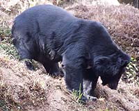 Wildlife experts in Indian-controlled Kashmir have fitted black bears with satellite-tracking collars to study their behaviour and help conserve the endangered animals, officials said Wednesday. "This is the first time in India that Himalayan black bears have been fitted with a GPS collar," wildlife warden Rashid Naqash told AFP, adding that there just 300 of the animals in the region. ... read more
Netherlands to levy 'green' road tax by the kilometre
 The Hague (AFP) Nov 13, 2009
The Dutch government said Friday it wants to introduce a "green" road tax by the kilometre from 2012 aimed at cutting carbon dioxide emissions by 10 percent and halving congestion. "Each vehicle will be equipped with a GPS device that tracks how many kilometres are driven and when and where. This data will be then be sent to a collection agency that will send out the bill," the transport min ... more
|
|
. |
Seeing Stars, Proba-2 Platform Passes Its First Health Check
 Paris, France (ESA) Nov 12, 2009
Into its second week in orbit, Proba-2's spacecraft platform has proven to be in excellent health. This leaves the way clear for commissioning the many new technology payloads aboard the mini-satellite, among the smallest ever flown by ESA. As ESA's full-sized Soil Moisture and Ocean Salinity (SMOS) mission soared skyward by Rockot launcher on 2 November, it had a smaller companion. ... more
NGC TRo Supply AHRS For NEURON European UCAV Demo Project
 Freiburg, Germany (SPX) Nov 12, 2009
Northrop Grumman has been awarded a contract by Saab Aerosystems to deliver Attitude and Heading Reference Systems (AHRS) for the NEURON European unmanned combat aerial vehicle (UCAV) demonstrator. The LCR-100 AHRS units will be built by the company's German navigation systems subsidiary, Northrop Grumman LITEF. The LCR-100 Gyrocompass AHRS is a north finding attitude and heading reference ... more
Maintaining NASA's Course To Moon And Mars Is Right Choice
 Bethesda MD (SPX) Nov 09, 2009
The U.S. human space program and the creation of new technologies for all humans are in peril if NASA deviates from its plan to explore the Moon and Mars. NASA should stay the course. A committee led by former Lockheed Martin CEO, Norm Augustine, has developed several options and recommendations for NASA that, if implemented, would have to be thoroughly evaluated before NASA could move for ... more
|
. |
|

|
|
. |
LockMart GPS Satellite Achieves 10 Years Of On-Orbit Operations
 Newtown PA (SPX) Nov 03, 2009
The third Global Positioning System Block IIR (GPS IIR-3) satellite, designed and built by Lockheed Martin to provide significantly improved navigation capabilities for military and civilian users worldwide, has reached 10 years of successful on-orbit operational service. The satellite was launched on Oct. 7, 1999, and is one of 30 GPS spacecraft currently on-orbit, providing critical ... more
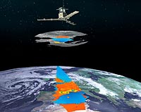
Eurockot Launches SMOS And Proba-2
 Plesetsk, Russia (ESA) Nov 02, 2009
The second satellite in ESA's Earth Explorer series-the Soil Moisture and Ocean Salinity (SMOS) mission-and the second demonstration satellite under ESA's Project for Onboard Autonomy (Proba-2) were launched into orbit last night from northern Russia. SMOS will play a key role in the monitoring of climate change on a global scale. It is the first ever satellite designed both to map sea sur ... more
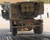
Raytheon Completes Free Flight Of Joint Standoff Weapon Extended Range
 Naval Air Warfare Center CA (SPX) Nov 03, 2009
Raytheon and the U.S. Navy completed the first free-flight demonstration of the Joint Standoff Weapon Extended Range air-to-surface precision guided missile. The JSOW-ER is a powered variant of the combat-proven glide JSOW. It takes the GPS-inertial navigation system reliability of existing JSOW variants and combines it with the network-enabled maritime-interdiction capabilities currently ... more
|
. |
|
| The contents herein, unless otherwise known to be public domain, are Copyright 1995-2009 - SpaceDaily. AFP and UPI Wire Stories are copyright Agence France-Presse and United Press International. ESA Portal Reports are copyright European Space Agency. All NASA sourced material is public domain. Additional copyrights may apply in whole or part to other bona fide parties. Advertising does not imply endorsement, agreement or approval of any opinions, statements or information provided by SpaceDaily on any web page published or hosted by SpaceDaily. Privacy statement |
|