 OGC standards ensure that maps and other location information (such as this digital elevation model showing Katherine Gorge in the Northern Territory of Australia) can be delivered to your computer or phone. Image credit - CSIRO |
The OGC is an international non-profit standards development organisation delivering standards that help make spatial information accessible and usable for a wide variety of purposes within sectors such as: geoscience, aviation, meteorology, oceanography and defence. These sectors require spatial data to be easily transferrable within and between organisations.
This week, the OGC will be holding its Technical Committee Meeting in Australia for the first time.
"It's a great opportunity for CSIRO and others in Australia to demonstrate our expertise in this area," said CSIRO Water for a Healthy Country Flagship scientist, Dr David Lemon.
The members of the OGC work together to produce standards for spatial encodings and service interfaces which allow spatial information to be seamlessly integrated into a wide range of business, government and consumer applications.
"Scientists at CSIRO have developed a suite of products and tools to design and implement common data exchange formats and content and we will be holding a Master Class to share the experience and knowledge we gained while developing these products for application in geological, hydrological, climate and biodiversity domains," Dr Lemon said.
The OGC is an international consortium of more than 400 companies, government agencies, research organizations and universities participating in a consensus process to develop publicly available geospatial standards.
OGC Standards support interoperable solutions that "geo-enable" the Web, wireless and location-based services, and mainstream IT.
CSIRO has been a member of the OGC since 1995.
 del.icio.us del.icio.us |
 Digg Digg |
 Reddit Reddit |
 YahooMyWeb YahooMyWeb |
 Google Google |
|
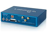 New Simulator Offers Ability To Record And Replay GLONASS And GPS
| The content herein, unless otherwise known to be public domain, are Copyright 1995-2010 - SpaceDaily. AFP and UPI Wire Stories are copyright Agence France-Presse and United Press International. ESA Portal Reports are copyright European Space Agency. All NASA sourced material is public domain. Additional copyrights may apply in whole or part to other bona fide parties. Advertising does not imply endorsement,agreement or approval of any opinions, statements or information provided by SpaceDaily on any Web page published or hosted by SpaceDaily. Privacy Statement |