GPS DAILY TERRA DAILY SPACE DAILY SPACE WAR MARS DAILY SPACE TRAVEL ABC SOLAR ENERGY DAILY
  GPS News  
Get Our Free Newsletters Via Email
  
Search All Our Sites at SpaceBank
Two Years In Space For Galileo Satellite

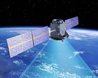
GIOVE-A - the first Galileo satellite.
by Staff Writers
Paris, France (SPX) Dec 20, 2007
On 28 December, it will be two years since GIOVE-A - the first Galileo satellite - was launched by a Soyuz rocket from Baikonur, in Kazakhstan. This satellite demonstrates the progress Europe has made in setting up its own navigation system. Since January 2006, Galileo signals have been broadcast by GIOVE-A, and received all around the globe.

At ESA's research and technology centre in the Netherlands, a laboratory is checking both the instruments on board the spacecraft that generate the signals and the receivers on the ground. This testing and calibration has allowed the specialists to confirm the success of the mission, which is a good sign for the rest of the programme.

The next step is well under way, with GIOVE-B - the second experimental satellite - finishing its preparations for launch in ESA's test facilities. This second Galileo satellite will embark the most accurate atomic clock ever flown in space, which will contribute to the quality of the performance of the Galileo system.

After GIOVE-B, the validation in orbit will be completed with the launch of four further satellites - the minimum required to obtain a satellite navigation position measurement. These satellites are currently being built at locations across Europe, for launch from the end of 2009.

To reach operational status, Galileo needs a constellation of 30 satellites and an associated network of ground stations spread all around the globe. This phase has just been confirmed with the decisions taken by the European Union, which has agreed on a financing package of 3.4 billion Euros and proposed to entrust ESA with the full deployment of Galileo by 2013.

While waiting for Galileo, another positioning system is in its pre-operational phase in Europe. EGNOS, the European Geostationary Navigation Overlay System, is a network of ground stations that improves GPS signals and retransmits them via geostationary satellites. EGNOS allows position determination accurate to within two metres. Originally designed to improve air traffic safety, EGNOS is accessible to all and paves the way for Galileo.

With these steps, the European Commission and ESA are progressively setting up a civilian system able to offer guidance and help worldwide.

Community
Email This Article
Comment On This Article

Related Links
Galileo
GPS Applications, Technology and Suppliers


Lockheed Martin-Built GPS Satellite Poised For Liftoff From Cape Canaveral Launch Pad
Cape Canaveral FL (SPX) Dec 18, 2007
The fifth in a series of eight modernized Global Positioning System Block IIR (GPS IIR-M) satellites built by Lockheed Martin for the U.S. Air Force is ready for launch aboard a Delta II rocket on Dec. 20, from Cape Canaveral Air Force Station, Fla. The spacecraft, designated GPS IIR-18M, is a modernized version of the Block IIR series designed to enhance the GPS constellation for military and civilian GPS users around the globe.


Memory Foam Mattress Review

Newsletters :: SpaceDaily Express :: SpaceWar Express :: TerraDaily Express :: Energy Daily
XML Feeds :: Space News :: Earth News :: War News :: Solar Energy News
  • Airbus close to sale of four factories: report
  • California urges regulation on aircraft emissions
  • Announcement Of Opportunity For Sounding Rocket And Balloon Flights
  • China to order up to 150 Airbus jets during Sarkozy visit: report

  • Bush signs bill raising auto fuel standards
  • US Congress raises auto fuel standards, boosts biofuels
  • German carmakers up in arms over EU emission limits
  • Automakers scramble to cut pollution as EU poised to act on emissions

  • Raytheon Technology Receives High Marks At Coalition Warrior Interoperability Demonstration
  • Northrop Grumman And L-3 To Work Together In Bid For US Navy's EPX Aircraft
  • Northrop Grumman Develops World's Fastest Transistor To Support Military's Need For Higher Frequency And Bandwidth
  • Russia launches military satellite: agencies

  • Japan Test Fires Its First Raytheon-Built Standard Missile-3
  • Israel test fires improved Patriot missile
  • Japan to conduct missile interceptor test next week: official
  • Czech govt calls Russian missile warning 'unimaginable': report

  • Jekyll And Hyde Bacteria Offer Pest Control Hope
  • Fish Farms Drive Wild Salmon Populations Toward Extinction
  • Moss Is A Super Model For Feeding The Hungry
  • A High Rise Apartment Complex With Built-In Greenhouse

  • Progress solid on Indonesian tsunami reconstruction: donors
  • A Gizmo That Saves Lives
  • Indonesia hands over 100,000th tsunami house in Aceh
  • Death toll from Tropical Storm Olga rises to at least 40

  • Efficiency Of Satellite Telecommunications For Civil Protection Agencies
  • Russia And France Developing New Satellite Platform
  • Light Is Shed On New Fibre's Potential To Change Technology
  • Major Physics Breakthrough In Understanding Supersolidity

  • Honda's ASIMO robot gets smarter
  • Toyota's new robot can play the violin, help the aged
  • Humanoid teaches dentists to feel people's pain: researchers
  • Japan looks at everyday use of robots

  • The content herein, unless otherwise known to be public domain, are Copyright 1995-2007 - SpaceDaily.AFP and UPI Wire Stories are copyright Agence France-Presse and United Press International. ESA Portal Reports are copyright European Space Agency. All NASA sourced material is public domain. Additional copyrights may apply in whole or part to other bona fide parties. Advertising does not imply endorsement,agreement or approval of any opinions, statements or information provided by SpaceDaily on any Web page published or hosted by SpaceDaily. Privacy Statement