GPS DAILY TERRA DAILY SPACE DAILY SPACE WAR MARS DAILY SPACE TRAVEL ABC SOLAR ENERGY DAILY
  GPS News  
Get Our Free Newsletters Via Email
  
Search All Our Sites at SpaceBank
NavCom Expands StarFire System And Extends RTK Capabilities

StarFire, the first of its kind, is a global satellite-based augmentation system (GSBAS) that provides decimeter positioning accuracy on a worldwide basis, completely independent of geographical boundaries, allowing users to roam freely while maintaining precise positioning.
by Staff Writers
Torrance CA (SPX) Jun 16, 2008
NavCom Technology has announced the release of new software for its RTK and StarFire products providing users access to an expanded StarFire Network of six satellites and NavCom's new Ultra RTK capability.

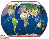
By increasing the StarFire constellation from three to six satellites, users are now provided with fully redundant global coverage as well as increased performance assurance as the GPS receiver now automatically selects the highest elevation satellite out of the six available.

Three new uplink sites were added in Santa Paula, CA; Southbury, CT; and Auckland, New Zealand ensuring true diversity of delivery and enhancing StarFire system redundancy.

The new software provides several new and enhanced features such as Ultra RTK, which allows RTK accuracy (0.5cm +1ppm) at up to 40km from the base station. Combined with NavCom's industry-exclusive RTK Extend, users can work farther away from base stations and maintain RTK-level accuracy even during radio outages.

"We are pleased to provide our clients with our latest technology with the release of this new software that gives our customers access to an expanded StarFire network and our newest enhancement - Ultra RTK," said Steve Wilson, NavCom's GNSS Business Manager.

"The expanded StarFire Network, combined with our Ultra RTK and RTK Extend capabilities, provides a powerful combination that helps reduce outages while providing extended coverage, saving our users valuable time and effort."

StarFire, the first of its kind, is a global satellite-based augmentation system (GSBAS) that provides decimeter positioning accuracy on a worldwide basis, completely independent of geographical boundaries, allowing users to roam freely while maintaining precise positioning.

Community
Email This Article
Comment On This Article

Share This Article With Planet Earth
del.icio.usdel.icio.us DiggDigg RedditReddit
YahooMyWebYahooMyWeb GoogleGoogle FacebookFacebook


Related Links
NavCom Technology
GPS Applications, Technology and Suppliers


Pep Boys Has The Gifts Dads Want This Father's Day
Philadelphia PA (SPX) Jun 16, 2008
The Pep Boys - Manny, Moe and Jack offers some exciting last-minute gift ideas for dad this Father's Day. Make your Father's Day celebration one to remember with these great gift ideas:


Memory Foam Mattress Review

Newsletters :: SpaceDaily Express :: SpaceWar Express :: TerraDaily Express :: Energy Daily
XML Feeds :: Space News :: Earth News :: War News :: Solar Energy News
  • The Tu-144: The Future That Never Was
  • China's new jumbo-jet firm no threat to Airbus, Boeing: state media
  • China unveils new jumbo jet company: report
  • NASA And JAXA To Conduct Joint Research On Sonic Boom Modeling

  • Rising Diesel Prices Renew Interest In Fuel-Saving Technologies For Heavy Trucks
  • New Apartment Building Lets You Drive Your Car All The Way Home
  • German coalition agrees on green car tax
  • Analysis: Hybrid trucks lag behind cars

  • An AFSCN Legacy Satellite Control System's Last Stand
  • Northrop Grumman And DHS Systems Receive Contract For Mobile Command Posts
  • LockMart Completes Major Hardware Integration Milestone On Second Advanced EHF Satellite
  • Lockheed Martin To Upgrade Battle Management System For USAF

  • The Russian US ABM Deadlock Continues Part Two
  • US to press NATO allies on missile defence options
  • Rice expected to sign Czech radar deal at start of July: report
  • Poland would let Russia inspect missile site: report

  • Drought emergency declared in vital California farmland
  • EU to shut down industrial bluefin tuna fishing early
  • Different Production Methods For Rice Fortification In Developing Nations
  • Scientists warn G8 of climate peril to food

  • Exercise For Rapid Disaster Relief With Space-Based Technologies
  • Cyclone dead wash ashore on distant Myanmar beach: official
  • Quake hits car, electronics factories in northern Japan
  • Reporters kicked out of China city where schools collapsed

  • Students Prepare For Dust Up In Space
  • Microsoft Surface computers hit Las Vegas party scene
  • Measuring How Much Information There Is In The World
  • Paralysed man takes a walk in virtual world

  • Energy ministers get 'buddy' humanoids
  • TU Delft Robot Flame Walks Like A Human
  • A Biomimetic Jumping Microrobot
  • Robot conducts Detroit orchestra

  • The content herein, unless otherwise known to be public domain, are Copyright 1995-2007 - SpaceDaily.AFP and UPI Wire Stories are copyright Agence France-Presse and United Press International. ESA Portal Reports are copyright European Space Agency. All NASA sourced material is public domain. Additional copyrights may apply in whole or part to other bona fide parties. Advertising does not imply endorsement,agreement or approval of any opinions, statements or information provided by SpaceDaily on any Web page published or hosted by SpaceDaily. Privacy Statement