GPS DAILY TERRA DAILY SPACE DAILY SPACE WAR MARS DAILY SPACE TRAVEL ABC SOLAR ENERGY DAILY
  GPS News  
Get Our Free Newsletters Via Email
  
Search All Our Sites at SpaceBank
Galileo To Support Global Search And Rescue

Search and rescue transponders on geostationary satellites can constantly view a large, fixed area of the Earth, thereby eliminating the time delay in detecting distress signals. However, they are not able to automatically determine the location of the distress beacon as the low-Earth orbit system does. They have to rely on the beacon to use a navigation system to find its position and include it in the distress call.
by Staff Writers
Paris, France (ESA) Aug 10, 2007
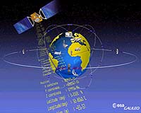
The detection of emergency beacons will be greatly improved by the introduction of Europe's satellite positioning system, Galileo. The Galileo satellites will carry transponders to relay distress signals to search and rescue organisations. In connection with this, representatives of the Galileo project attended the recent 21st annual Joint Committee Meeting of COSPAS-SARSAT, the international programme for satellite-aided search and rescue.

The partners in Galileo are committed to developing the Galileo search and rescue component as an integral part of MEOSAR, the future worldwide search and rescue satellite system.

Galileo joined the meeting in a formal capacity as a major contributor to the MEOSAR programme, following the signature of the 'Declaration of Intent to Cooperate on the Development and Evaluation of MEOSAR'. MEOSAR, which stands for Medium Earth Orbit Search And Rescue, is a programme to equip satellites that operate in medium-Earth orbits with payloads that receive signals from distress beacons on Earth. These signals are then relayed to rescue organisations, giving them the location of the emergency.

Existing systems
COSPAS-SARSAT already has systems operating in low-Earth orbit and geostationary orbit. The low-Earth orbit satellites can determine the location of emergency beacons using the Doppler effect as they pass overhead. However, there is a delay in relaying the distress signal because the satellites can only 'see' a part of the Earth's surface at any given time and a beacon is only detected when the satellite passes nearly overhead. Also, the satellites have to store the location of the emergency and transmit it to a ground station once one comes into in range, causing a further delay.

Search and rescue transponders on geostationary satellites can constantly view a large, fixed area of the Earth, thereby eliminating the time delay in detecting distress signals. However, they are not able to automatically determine the location of the distress beacon as the low-Earth orbit system does. They have to rely on the beacon to use a navigation system to find its position and include it in the distress call.

Emergency beacons need to have a direct line-of-sight to the geostationary satellites. There are some situations where this is impossible, such as near the Earth's poles, where the satellites are too low in the sky to be usable, or when an accident happens on the 'wrong' side of a mountain or in a deep valley, and the surrounding terrain obscures the satellite.

Future improvements
To further improve the performance of the overall COSPAS-SARSAT system, plans are now being made to fly search and rescue payloads on future navigation satellites. The various navigation satellite constellations will each have about 20 to 30 satellites in medium-Earth orbit, providing global coverage, including at the Earth's poles, and with multiple viewing angles to the satellites, eliminating terrain blocking.

The Galileo search and rescue component will provide two services. The Forward Link Alert Service, fully backward compatible with the current operational COSPAS-SARSAT components and interoperable with all other planned MEOSAR elements, detects activated distress beacons and notifies the appropriate rescue body. A novel service, known as the Return Link Service, will send a return message to the emergency beacon, notifying the emergency victims that their distress signal has been received and help is on its way.

The Galileo In-Orbit Validation Programme, which will have four satellites fitted with search and rescue transponders, will demonstrate the Galileo MEOSAR services.

Galileo is a joint initiative between ESA and the European Commission. When fully deployed in the early years of the next decade, it will be the first civilian positioning system to offer global coverage.

Community
Email This Article
Comment On This Article

Related Links
Galileo website (European Commission)
European GNSS Supervisory Authority (GSA)
COSPAS-SARSAT
GPS Applications, Technology and Suppliers


Car Satellite Navigation Systems Can Be Steered The Wrong Way
Las Vegas (AFP) Aug 3, 2007
Satellite navigation systems in cars can be hijacked remotely with relative ease, allowing hackers to feed drivers bogus directions, two experts told a major security conference here. Andrea Barisani and Daniele Bianco from the website Inverse Path demonstrated Thursday how antennas and a patchwork of commonly available electronics can be employed to replace the legitimate traffic information radioed to the systems with false instructions.


Memory Foam Mattress Review

Newsletters :: SpaceDaily Express :: SpaceWar Express :: TerraDaily Express :: Energy Daily
XML Feeds :: Space News :: Earth News :: War News :: Solar Energy News
  • Boeing Flies Blended Wing Body Research Aircraft
  • Steering Aircraft Clear Of Choppy Air
  • EAA AirVenture 2007
  • Sensors May Monitor Aircraft For Defects Continuously

  • Driving Changes For The Car Of The Future
  • Toyota To Delay Launch Of New Hybrids
  • US Should Consider Gas Tax Says Ford Chief
  • GM Sales In China To Hit One Million Vehicles

  • Boeing TEAM TSAT Demonstrates Technology Maturity
  • Lockheed Martin Awarded B-2 Bomber Satellite Communication System Upgrade Contract
  • Northrop Grumman Tests Airborne Networking System For Aeronautical and Land Vehicular Broadband Services
  • TSAT Teams Submit Production Proposals To US Air Force

  • Russia To Boost Space Defense With New Missile System
  • Japan Buys Another Aegis System
  • Russia To Export S-400 Air Defense System From 2009
  • Northrop Grumman Delivers SBIRS GEO-1 Payload To Lockheed Martin

  • 'Worrisome signs' for global rice crop
  • Conventional Plowing Is Skinning Our Agricultural Fields
  • Chinese Prosperity Will Set Off Global Food Inflation
  • Risk Of Contamination Rises As Global Food System Expands

  • Spectre of hunger looms over flood-hit India
  • Medics fight disease after SAsia floods
  • Floods Test Army-Backed Bangladesh Rulers
  • WMO Says World Hit By Record Extreme Weather Events In 2007

  • ATK To Build Satellite Link Signal Generator With Sandia National Laboratories
  • Purdue Milestone A Step Toward Advanced Sensors And Communications
  • Bridges Too Far As Infrastructure Ages Across The Old West
  • Lockheed Martin Completes Key End-To-End Test Of Space Based Infrared System

  • Successful Jules Verne Rendezvous Simulation At ATV Control Centre
  • Robotic Einstein Wows Spanish Technology Fair
  • Robotic Ankle For Amputees Is Developed
  • iRobot Receives New Military Orders 14 PackBot Robots

  • The content herein, unless otherwise known to be public domain, are Copyright 1995-2007 - SpaceDaily.AFP and UPI Wire Stories are copyright Agence France-Presse and United Press International. ESA Portal Reports are copyright European Space Agency. All NASA sourced material is public domain. Additional copyrights may apply in whole or part to other bona fide parties. Advertising does not imply endorsement,agreement or approval of any opinions, statements or information provided by SpaceDaily on any Web page published or hosted by SpaceDaily. Privacy Statement