|
 China launches orbiter for navigation system: state media
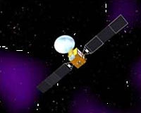
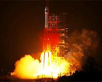
Beijing (AFP) Jan 17, 2010 China launched an orbiter into space early Sunday, the latest stage in the development of its own satellite navigation system, state media said. The orbiter, launched at about 00:12 am (1612 GMT Saturday) was the third orbiter that China has launched for its Beidou Navigation System, Xinhua news agency said. "(The orbiter) will join another two already in orbits to form a network which will eventually have a total of 35 satellites, capable of providing global navigation service to user ... read more |
. |
|
|
Free Space, Earth, Energy And Military Newsletters - Delivered Daily |
| . | . |
| .. |
 Bethesda MD (SPX) Jan 27, 2010
Over the past few decades NASA and other organizations have attempted to design satellites that would be capable of carrying out multiple missions. The fundamental idea is to create a single spacecraft design that could be duplicated over and over in order to reduce unit costs while satisfying several space missions and applications. To date, the results have been disappointing. The spacec ... more  Chandigarh, India (PTI) Jan 27, 2010
Haryana is among five states selected for the implementation of a project designed by the Indian Space Research Organisation (ISRO) for carrying out developmental activities through local bodies. The major Remote Sensing and GIS Application project entitled 'Space Based Information Support for Decentralized Planning (SIS-DP)" of ISRO will be implemented in Andhra Pradesh, Assam, Kerala and ... more Spot Image and Infoterra are pleased to announce the signing of an agreement with Google to be a partner for Google Earth Enterprise. Spot Image and Infoterra have been a Google Earth content partner for a number of years, providing ready to use imagery to Google as well as to Google Earth Enterprise users. Spot Image and Infoterra will be able to provide customised Google Earth Enterprise ... more |
.. |
 USA And Japan Convene On GNSS Status First Quasi-Zenith Satellite Named "MICHIBIKI"  Instant online solar energy quotes Solar Energy Solutions from ABC Solar |
.. |
|
|
Free Space, Earth, Energy And Military Newsletters - Delivered Daily |

|
. |
 Nokia says to offer free maps to smartphone users
Helsinki (AFP) Jan 21, 2010 Nokia, the world's top mobile phone maker, will offer free maps and navigation services for its smartphone users, it said Thursday in a move that puts pressure on players in the GPS industry. "We are offering global car and pedestrian navigation in 74 countries, in 46 languages ... Ovi Maps becomes completely free from this moment onwards," Jukka Hosio, director of Nokia's services marketing, told a press conference in Helsinki. The move follows and takes a step further a similar play ... read more |
| The contents herein, unless otherwise known to be public domain, are Copyright 1995-2010 - SpaceDaily. AFP and UPI Wire Stories are copyright Agence France-Presse and United Press International. ESA Portal Reports are copyright European Space Agency. All NASA sourced material is public domain. Additional copyrights may apply in whole or part to other bona fide parties. Advertising does not imply endorsement, agreement or approval of any opinions, statements or information provided by SpaceDaily on any web page published or hosted by SpaceDaily. Privacy statement |
| Previous Issues | Feb 03 | Feb 02 | Feb 01 | Jan 29 | Jan 28 |