|
|
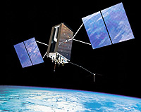
Cape Canaveral FL (SPX) Aug 18, 2009  The 48th successful and final Air Force Delta II Global Positioning System satellite launch occurred today, ending one of the most successful space launch programs in American history. A United Launch Alliance Delta II rocket launched GPS IIR-21(M) into orbit from Space Launch Complex-17A at 6:35 a.m., EDT today. The first Air Force Delta II GPS launch occurred Feb. 14, 1989 and today's ... read more
 Madison WI (SPX) Aug 18, 2009
Grassed waterways are placed in agricultural fields where runoff water tends to concentrate because they can substantially reduce soil erosion. Mapping techniques that help identify where erosion channels will likely form could help farmers and conservation professionals do a better job of designing and locating grassed waterways in agricultural fields. Tom Mueller, associate professor in ... more
|
| |||||||||||||||
| Previous Issues | Aug 17 | Aug 16 | Aug 13 | Aug 12 | Aug 11 |
| . |
 Concord MA (SPX) Aug 18, 2009
Everyday Solutions has announced that Charlotte County Public Schools (CCPS) based in Port Charlotte, FL has standardized on GPS-driven applications from Everyday Solutions. "We expect to see many benefits from using Everyday Solutions' GPS-driven applications to manage our school bus fleet." says Richard Duckworth, Transportation Director at CCPS. "Accurate GPS information will ... more  Arlington VA (SPX) Aug 18, 2009
System Planning and Powers International have announced a licensing agreement to offer the Powers-Secured Chain-of-Custody feature on SPC's GlobalTrak asset tracking and monitoring system. Under the licensing agreement, the GlobalTrak system will have the rights to offer the additional Powers-Secured capability of identifying a trusted agent overseeing the stuffing of the container and the ... more Trimble has introduced the Trimble AP Series of embedded GNSS-Inertial OEM boards plus an Inertial Measurement Unit (IMU) in a compact form factor. The combined technology allows system integrators to add precise multi-frequency GNSS positioning and inertial data capabilities to their systems to provide continuous mobile positioning and high-accuracy orientation in poor signal environments. ... more |
. |
|
|
. |
 Redlands CA (SPX) Aug 10, 2009
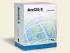
ESRI has released an updated version of ArcGIS Business Analyst desktop software, which includes new features designed to optimize geographic analysis for businesses. ArcGIS Business Analyst desktop enables location-based analysis with updated demographic and lifestyle segmentation data, allowing analysts to place customer and company data into a geographic context. In a slow economy ... more  Hanscom AFB MA (AFNS) Aug 07, 2009
Last month's award of three $30-million concept development contracts for the Space Fence program will yield an outcropping of risk reduction activities designed to improve the overall space surveillance network. "This is truly a classic multi-contractor, prototyping risk-reduction effort, and a return on the investment of the program to gather data to improve the follow-on phases," said L ... more Iridium Satellite announces that, in conjunction with Boeing, the companies have achieved two major milestones to further develop and demonstrate capability enhancements to the High Integrity Global Positioning System (GPS) program for the U.S. Naval Research Laboratory. The first milestone, completion of an Enhanced Narrowband (ENB) software modification to computers on Iridium satellites ... more |
. |
| Previous Issues | Aug 17 | Aug 16 | Aug 13 | Aug 12 | Aug 11 |
| The contents herein, unless otherwise known to be public domain, are Copyright 1995-2009 - SpaceDaily. AFP and UPI Wire Stories are copyright Agence France-Presse and United Press International. ESA Portal Reports are copyright European Space Agency. All NASA sourced material is public domain. Additional copyrights may apply in whole or part to other bona fide parties. Advertising does not imply endorsement, agreement or approval of any opinions, statements or information provided by SpaceDaily on any web page published or hosted by SpaceDaily. Privacy statement |